Geoscience Reference
In-Depth Information
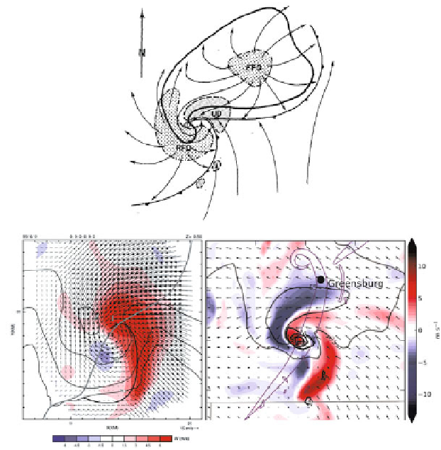
Figure 4.15. (Top) Conceptual model of the major vertical air currents in a supercell (from
Lemon and Doswell, 1979), showing the rear-flank gust front (cold front symbol) ahead of the
rear-flank downdraft (RFD), the main updraft (UD), the forward-flank downdraft (FFD), and
a warm/stationary/cold front-like boundary (with the appropriate symbols) separating air
underneath the FFD from ambient air (streamlines indicate the flow field near the ground).
Tornado location is indicated by the ''T''. Updrafts are indicated by finely stippled areas;
downdrafts are indicated by coarsely stippled areas. Radar echo associated with the storm
outlined by solid line. (Bottom, left) Pseudo dual-Doppler analysis of storm-relative winds in a
tornadic supercell in the Texas Panhandle on June 8, 1995 from ELDORA data, at 550m
AGL. Vertical velocity is color-coded. ''T4'' indicates the tornado location at the time of the
analysis. The solid black line indicates the leading edge of the rear-flank gust front. The solid
gray line indicates the tornado track. The solid contours are radar reflectivity in dBZ
e
. Note the
RFD (purple) and main updraft (red). There is no general FFD or windshift along the leading
edge of an FFD as in the Lemon and Doswell conceptual model (courtesy of David Dowell).
(Bottom, right) Ensemble mean vertical velocity color-coded and storm-relative ensemble
mean wind (plotted every 2 km) from mobile Doppler radar data from the U. Mass. X-Pol
radar and data from the WSR-88D radar at Dodge City, KS, on May 4, 2007, in south central
Kansas, assimilated into a numerical cloud model. Tornado paths are indicated by thin purple
lines and radar reflectivity factor (dBZ) is contoured at 35 and 55 dBZ in gray. There again is
no windshift along the edge of an FFD. In this case, however, the RFD is connected to the
FFD, while both the RFD and the main updraft are broken up into two sections (courtesy of
Robin Tanamachi).
Search WWH ::

Custom Search