Geoscience Reference
In-Depth Information
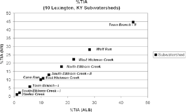
Fig. 8.5
Percentage of total impervious area (%TIA); all 10 subwatersheds
8.3 The Effects of Temporal Land Cover Change
on Imperviousness
Landscapes are not static and are always changing. Impervious cover is a critical
hydrologic factor for watershed management, but far be it from being a static prop-
erty, the problem is often reduced to knowing where, how much, and when this
landscape attribute changed. The increase in urban development across the state was
demonstrated for the 2001-2005 period, but there is neither older nor more recent,
specific imperviousness datasets, other than the “baseline” set for 2001. Newer data
exist which are useful to look at more recent trends during what was considered to
be an era of economic growth and urbanization in the region.
This section of the chapter will focus on two aspects of using geotechnolo-
gies and data for environmental resource management. First, a method to quantify
spatial changes in imperviousness over time, covering a period between 1992 and
2005, while pivoting on the 2001 baseline imperviousness dataset is described.
Next, an analysis addresses increases in imperviousness in the context of spa-
tial overlap within the same subwatershed set. To provide temporal context to
the land cover class changes and conversion rates resulting in added imper-
viousness to urban and suburban watersheds, information was used from two
land cover change products, covering adjacent temporal windows - one quasi-
decadal, the other quadrennial. The 2001-2005 temporal land cover change product
for Kentucky has a documented accuracy and higher degree of class resolution
(Anderson Level II vs. Level I) (Palmer
2007
). Kentucky watersheds that had