Geoscience Reference
In-Depth Information
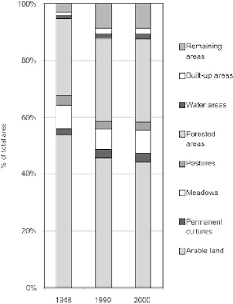
Fig. 6.6
Land-use changes in the subset Interior (
n
=
7,357) (Source: LUCC UK Database)
area in 2000), consisting both of fishing ponds and large reservoirs (e.g., Lipno to
the west and Nové Mlýny to the east). The share of built up areas is below average
in both subsets, demonstrating lower socio-economic activity and absence of larger
cities and concentrations of population.
Land-use changes had the same direction in both border subsets as in the interior
of the country in both time periods, implying a general character of these trends -
compare to Jelecek (2002) for the whole of Czechia; see ibid for explanation and
“driving forces” of these changes. However, the intensity of these changes was
different.
The first - socialist - time period (1948-1990) was typical of decreasing share
of arable land and permanent grasslands, and increasing share of forested, built up
and “remaining” areas. On the one hand, these processes were the result of growing
intensity of agriculture (with yields on fertile plots growing faster than consump-
tion leading to land abandonment elsewhere), of neglect of land that was worse
to work or access with heavy machinery, and of rapid and reckless urbanisation
and industrialisation on the other. Both studied border regions differed from the
interior particularly in a much faster transition of grasslands (especially meadows)
to forests - or of arable land to grasslands and grasslands to forests. The decline
of the share of grasslands was 7 pp in subset West Germany and 9 pp in subset
Search WWH ::

Custom Search