Geoscience Reference
In-Depth Information
Bicík, Jelecek, & Štepánek, 2001 or Bicík & Jelecek, 2003 for more details). In
this database, the whole area of Czechia is divided into 8,903 Basic Territorial Units
(BTUs), each consisting of one or more cadastres. Land-use structure of each BTU
is recorded in four time horizons, representing the main milestones of modern Czech
history - 1845 (before deeper impacts of market economy on land-use structure),
1948 (communist coup), 1990 (the “Velvet Revolution”) and 2000 (after ten years
of transformation). Eight basic land-use categories are recognised in this database:
arable land, permanent cultures (gardens + vineyards + orchards + hop gardens),
meadows and pastures (together permanent grasslands), forested areas, water areas,
built up areas and remaining areas (non-productive land, bare land, infrastructure,
mines, etc.).
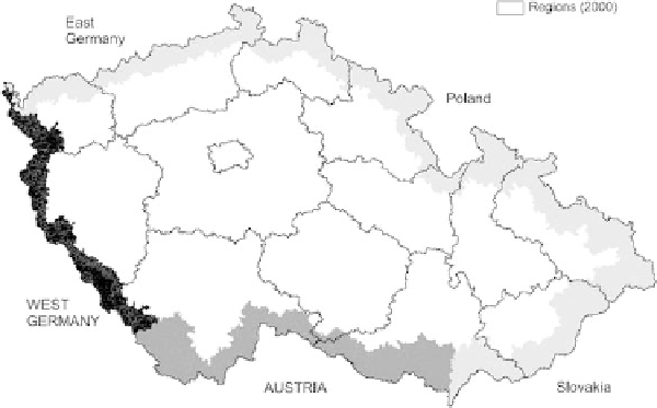
For the purpose of our research, we have defined several subsets of BTUs in
relation to their proximity to the state borders (see Bicík & Kabrda, 2008 for
more details). Firstly, we have defined three “belts” of BTUs along the borders
of Czechia. Subset “At border” (A) consists of BTUs adjoining/touching the bor-
der (
n
395). Subset “Intermediate” (B) consists of BTUs adjoining the BTUs
of subset A (
n
=
=
571). Subset “At interior” (C) consists of BTUs adjoining the
BTUs of subset B, excluding the BTUs of subset A (
n
=
580). The remain-
ing BTUs create subset “Interior” (O,
n
7,357). The first three subsets (belts
of BTUs) were then merged (A + B + C,
n
=
1,546) and divided according to
respective countries. Five subsets were defined in this way - former West Germany
(
n
=
=
288), former East Germany (
n
=
316), Poland (
n
=
491), Slovakia (
n
=
168) and Austria (
n
283). In this article, only two subsets with the countries
divided from Czechia by the Iron Curtain (West Germany and Austria) were stud-
ied, and compared to the characteristics of the Interior (see Fig. 6.1 for graphical
expression).
=
Fig. 6.1
Delimitation of subsets of BTUs according to their position towards borders (Source:
own calculations)
1
Search WWH ::

Custom Search