Geoscience Reference
In-Depth Information
population dropped to one quarter, and settlement structure significantly changed.
Of ten original settlements, only three remained. During the totalitarian period,
political power was also strongly pushing through. This meant waves of collectivi-
sation and “new” organisation of the countryside. Former tiny fields and meadows
were united under the terms of founding of Unified Agricultural Cooperatives (JZD)
or used for large-scale cattle husbandry. Partial transition from vegetable production
to animal farming, or deserting locations unsuitable for agricultural activities, is
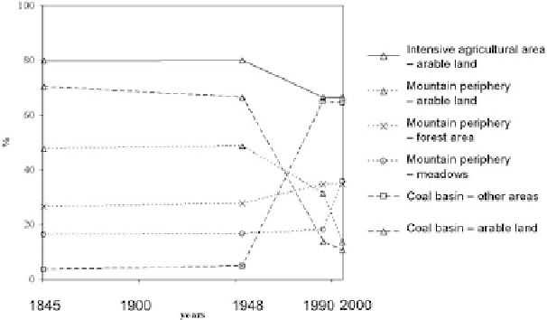
reflected in a change of land-use categories. There is a decrease of arable land (from
49 to 31%), in favour of forest (from 28 to 35%), meadows and pastures (from 18 to
24%, Fig. 7.2). The 1990s meant the disappearance of employment possibilities in
collective farms or in small industrial companies for the Petrovice area.
Nevertheless, this period provided an impulse for development of entrepreneurship,
especially in tourist industry services. (That's why arable land decreases from 30%
in 1990 to the current 13%; Fig. 7.2). This phenomenon shows itself particularly in
the eastern part of the region.
The Trebenice area is intensively used for agriculture, and through its devel-
opment shows stable structure of land-use categories (Fig. 7.2). The landscape
character of the Trebenice area and its function were affected the most by a wave of
collectivisation in the second half of the Twentieth century, in the totalitarian period.
During this epoch, tiny plots of arable land, cultivated until then by private farm-
ers, were united into vast fields. This collectivisation was ordered by state organs.
So the face of the landscape significantly changed. Many ridges, stands of trees,
woody accompaniments of streams and paths, “solitary” and specific alluvial plain
communities almost disappeared from the landscape. Typical agricultural vernacu-
lar architecture, church buildings and minor composing landscape elements were in
most cases destroyed. Most buildings in the Trebenice area are newly renovated for
Fig. 7.2
Land-use changes in the study areas; using selected land-use categories with the most
dynamic changes
Search WWH ::

Custom Search