Geoscience Reference
In-Depth Information
4
(a)
A
B
AA'
C
BB'
CC'
(b)
line of section in (c)
(c)
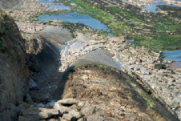
Figure 4.8
(a) Photograph of several plunging folds near Berwick-upon-Tweed, Northumberland, UK. (b) Detail
of (a) showing lines of cross-sections in (c). (c) Series of simple sketch cross-sections and a sketch map from a
fi eld notebook showing how the three-dimensional characteristics of these folds might easily be recorded in two
dimensions. The map could be improved by adding a numerical value for the strike direction of the axial traces.
(Photographs and notebook of Angela L. Coe, The Open University, UK.)
there is no point in reproducing detailed topographical maps
that are already published and which you can annotate instead.
The sketch map should add something new and useful. If you
need to produce an accurate geological map then your