Geoscience Reference
In-Depth Information
A
B
400
200
0
400
200
0
(a)
(vertical scale = horizontal scale)
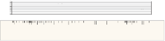
Decide on an appropriate vertical scale for the
cross-section. Mark the line of section on the map with
a faint line, or mark the end points. On a separate
sheet of graph paper, draw a straight horizontal line of
the same length, to represent mean sea level (the
usual reference datum). Add vertical axes at each end,
labelling them with an appropriate scale for the height
relative to sea level.
10
LSh
DCg
BRL
c
HL
BRL
PoB
48
BO
LSh
BO
CO
61
26
A
60
B
50
51
CdL
MMG
6777
6
piece of paper
DCg
(b)
topographic contours cross the section line mark ticks,
labelled with the contour height, on the second sheet of
paper. (It may help to mark rivers and ridge crests too.)
Lay the straight edge of a second sheet of paper along
the section line on the map. Mark the end points of the
section line on the edge of the paper, and wherever
N
400
200
0
S
A
B
400
200
0
67 77
6
(c)
Transfer the contour heights to the graph paper by
laying the edge of the paper along the horizontal axis,
and marking dots projected up to the correct height all
along the cross-section. Join these dots with a smooth
curve interpolated between them to produce a
topographic profile as a base for your cross-section.
Label the end points with a grid or GPS reference, or a
compass bearing.
LSh
BRL
DCg
c
HL
BRL
PoB
48
BO
LSh
BO
61
CO
26
A
60
B
50
51
CdL
MMG
BRL
BO
c
c
BRL
PoB
HL
BO
CdL
CO
LSh
HL
CDL
LSh
CDL
DCg
73 77 56
Angles between strike of beds and line of section (for calculating apparent dips)
69
65
80
(d)
map to the cross-section in the same way as you did
for the contour heights (stage (b)).
Using a third sheet of paper, transfer geological
information such as stratigraphic boundaries, faults
and igneous contacts along the line of section from the
Figure 10.19