Geoscience Reference
In-Depth Information
magnetic north
pole
Magnetic declination
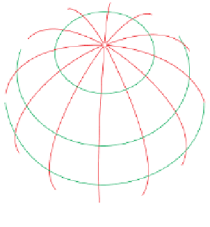
The Earth's rotational pole (true north) is not coincident with
magnetic north and varies by as much as 30° either side of true
north and even greater closer to the poles. Not only that, this
declination varies with geographical location
and
over time. On
maps the N-S grid lines are orientated as close as possible to
true north but again this varies by a very small amount
depending on your location. This is because grid systems are
rectangular but meridians (lines of longitude) converge towards
the Earth's pole (Figure 2.4).
true north
east
declination
west
declination
2
Before taking any azimuth readings it is strongly advised that
you adjust your compass for magnetic declination for the area
you are visiting and the year so that there are no resulting
errors in the azimuth measurement. It is a good idea to also
make a note of what you have done in your fi eld notebook so
that there is no ambiguity later. The less favoured alternative is
to make a note at the start of your fi eld notes for that locality
that the readings need adjusting for magnetic declination and
then to correct them after you return from the fi eld,
except,
that
is, if you are using your compass for triangulation to plot your
position (Section 2.3.3) or if you are plotting measurements
directly on the base map - i.e. the topographical map onto
which geological data will be added (Chapter 10). In this case
it must be adjusted at the time of the measurement if your
readings are to be accurate.
agonic line
(zero declination)
grid lines
Adjusting your compass to take the magnetic north variation
into account is easy. On the compass dial or side of the
compass there is a screw, the declination adjustment screw
(Figure 2.3a and e, pp.
8-9); turn this screw by the amount of
declination relative to grid north for the area and year using
either a screwdriver or, for the Silva-type, the tool provided. To
fi nd out how much the magnetic declination is for the area
there are three possibilities: (a) consult the legend of the
topographical map of the area, taking note of changes since the
publication date; or (b) use one of the many web pages now
available that will calculate the declination for the area where
you are completing fi eldwork; or (c) determine the declination
yourself in the fi eld as follows.
longitude (meridians)
latitude
(a)
(b)
1. Ensure that the magnetic declination on the compass-
clinometer is set to 0°.
Figure 2.4
(a) Simplifi ed sketch of the Earth to show the relationship
between magnetic declination, magnetic north, true north and, via the
inset, the longitude, latitude and a grid system (in this case the UK grid
squares). (b and c) Typical map information showing magnetic north, true
north and grid north. The adjustment of the magnetic declination is shown
by the red arrows; (b) is for a westerly declination of magnetic north from
true north and (c) is for an easterly declination.
(c)