Geoscience Reference
In-Depth Information
1
Introduction
Angela L. Coe
1
The main aim of fi eld geology is to observe and collect data
from rocks and/or unconsolidated deposits, which will further
our understanding of the physical, chemical and biological
processes that have occurred over geological time. Many of the
basic observational principles used in fi eld geology have not
changed for hundreds of years, although the interpretation of
the data, the scale of resolution and some of the equipment has
advanced greatly. Fieldwork involves making careful
observations and measurements in the fi eld (Figure 1.1a) and
the collection and precise recording of the position of samples
for laboratory analysis (Figure 1.1b). The very act of collecting
fi eld data often raises questions about processes on Earth,
which had perhaps not previously been envisaged.
Furthermore, during fi eldwork it is usual to initiate, or to build
on, constructing and testing different hypotheses and
interpretations based on the observations; this iterative process
will help to determine the essential data and samples to
collect.
(a)
This topic is divided into 14 chapters. Chapter 2 covers the
most commonly used fi eld equipment and outlines fi eld safety
procedures. Chapter 3 explores the general objectives of
fi eldwork and how to make a start. Chapter 4 is devoted to the
production of a fi eld notebook (hard copy or electronic), as this
is the key record of geological fi eld data. The bulk of the topic
comprises fi ve chapters covering the necessary skills for the
collection of palaeontological (Chapter 5), sedimentological
(Chapter 6), igneous (Chapter 7), structural (Chapter 8) and
metamorphic data (Chapter 9). Chapter 10 uses the fi eld
techniques covered in the previous fi ve chapters to introduce
geological mapping, where it is usually necessary to deal with
a range of rock types and different kinds of exposure
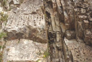
0.5 m
(b)
Figure 1.1
(a) Geologists
collecting data for a graphic log
(Section 6.3) to record how a
sedimentary succession has changed
through time and to decipher the
overall depositional environment.
By working together they can share
tasks and discuss their observations.
(b) The recessed bed marks the
Cretaceous-Paleogene boundary at
Woodside Creek, near Kekerengu,
New Zealand. Note the holes
where samples have been
extracted for palaeomagnetism
studies. In this case the number of
holes is rather excessive and
breaks the code of good practice
(Section 2.12 and Chapter 13). (a
and b: Angela L. Coe, The Open
University, UK.)
*. The
topic concludes with short chapters on recording numerical
and geophysical data (Chapter 11), photography (Chapter 12)
and sampling (Chapter 13).
*The term exposure is used to indicate areas where rocks are visible at the
Earth's surface. This is in contrast to the term outcrop which also encompasses
those areas where the rock is at the Earth's surface but is covered by superfi cial
deposits and soil.