Geoscience Reference
In-Depth Information
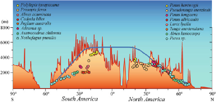
Fig. 7.1
Cross-section from the South to North Pole across the Western American Cordilleras
showing changes in elevation with latitude, the approximate location of the mean annual zero
degree (0
◦
C) line, and the distribution of upper-elevation tree-ring chronologies. Major tree taxa
used for developing the chronologies are also indicated
One of the Collaborative Research Networks supported by the Inter-American
Institute for Global Change Research (IAI) was focused around the develop-
ment of tree line chronologies from Alaska to Tierra del Fuego (Luckman and
some of the most significant developments in tree-ring research across the western
Americas, reviewing local- and regional-scale studies and how they contribute to
our understanding of present and past variations in the circulation modes of climate
variability at continental and interhemispheric scales. The Western Cordilleras of
the Americas runs transverse to the generally latitudinal organization of the major
climate-ocean circulation systems, and therefore past variations in the major modes
of general circulation dynamics linked to El Niño/Southern Oscillation, Pacific
Decadal Oscillation, the Arctic and Antarctic Oscillations can be investigated by
using tree-ring records from this global-scale transect.
7.2 Oscillatory Modes of Climate Variability Across the Western
Cordilleras
Instrumental records show that the climate system is characterized by low- and
high-latitude patterns or modes of variability. These dominant modes of climate
variability fluctuate at many different temporal scales. The best known is the El
Niño-Southern Oscillation phenomenon in the tropical Pacific, which dominates
global climate variations on interannual timescales, mostly ranging from 3 to 6
climate pattern in the Pacific Ocean has an ENSO-like spatial distribution of sur-
face temperature and atmospheric circulation and has been identified as the Pacific