Geoscience Reference
In-Depth Information
Cloud seeding
NEW DEVELOPMENTS
In many parts of the world either the total amount or the irregular distribution of rainfall means that serious deficiencies
can occur leading to water shortages. It has long been the desire of farmers to be able to persuade clouds to produce
precipitation at their command rather than waiting for natural precipitation to fall. Experiments have been conducted
since the 1940s but unfortunately they have not been particularly successful. For the realistic production of
precipitation, the natural processes have to be helped when there are factors limiting their operation. In other words,
we can achieve rainfall generation only when the right type of cloud already exists; we cannot produce clouds likely
to give rain from a cloudless atmosphere.
It has been found that the most likely circumstances suitable for precipitation formation, or cloud seeding, as it is
known, is when there are plenty of water droplets within the cloud, but there are insufficient ice nuclei to assist the
enlargement of the water droplets. By adding artificial ice nuclei, such as silver iodide, or by freezing existing water
droplets though adding frozen carbon dioxide (dry ice), under the right circumstances, precipitation can be produced.
Such clouds are most likely to exist over mountain ranges, such as the Rockies, where moist air rising over the
mountains produces the clouds but not necessarily precipitation. Experiments of adding dry ice to such clouds have
led to an increase in snowfall. In many places the results have been less clear. The complexity of atmospheric
processes in precipitation formation makes it difficult to produce statistically convincing results of enhancement.
Areas worst affected by drought rarely have the right sort of clouds on which to conduct the experiments, so we
cannot produce precipitation at will.
However, in the 1990s cloud seeding experiments were started in South Africa by adding potassium and sodium
chloride in flares just below cloud base. As these two salts attract moisture, they quickly formed large water droplets
in the cloud. The development of this approach was initiated by radar and cloud observations near a large paper mill
which indicated greater cloud development near the chimney plume than elsewhere. Radar measurements indicated
that seeded clouds produced about 30 per cent more rain than unseeded clouds. Further experiments have been
conducted in Mexico and Thailand with some evidence of support for the South African results, but many scientists
are still cautious about the prospects of cloud seeding.
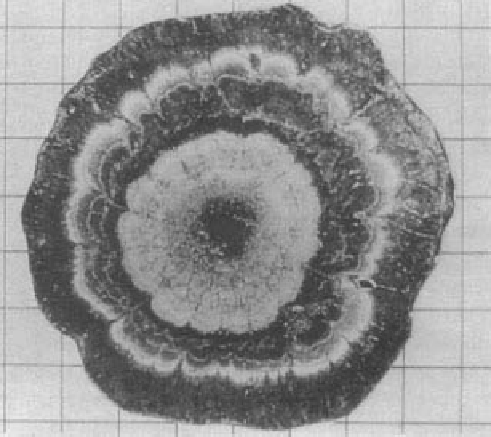
number of times the hailstone has been swept up by the
cloud updraughts.
Convergent precipitation
In temperate and subpolar latitudes most of the pre-
cipitation comes from depressions. They are characterized
by areas of rising air associated with convergence. A
satellite photograph of a cyclone shows the extensive areas
of cloud resulting from this slow but widespread ascent
There are a number of differences from convectional
precipitation. The areal extent of rising air associated with
a depression is much larger, and the rate of upward
movement and the rate of condensation in the generally
stratiform clouds are much less. Because of this, the
droplets grow more slowly and fall out of the cloud sooner.
Being small, they can be greatly affected by evaporation
in the drier air beneath cloud base. For example, in an
atmosphere with a relative humidity of 90 per cent, a
droplet of radius 10 μm will fall only 3 cm before
Plate 4.8
Section across the centre of a large hailstone,
appear black and milky or opaque ice which appears white.
Photo: courtesy of Dr K. A. Browning