Geoscience Reference
In-Depth Information
(a)
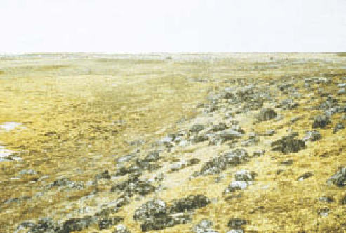
landscape or from an aircraft gives a false impression of
monotonous uniformity, whereas there is large spatial
variety on the ground.
A topographic catena of soils and vegetation com-
munities at Rankin Inlet, Canada, on the western coast of
Hudson Bay in the Low Arctic heath tundra zone
is shown in
Figure 24.18
.
Topography and depth-to-
permafrost are crucial in influencing vegetation and soils.
Ridges of glacial till or sand and gravel have a xeric
vegetation of lichens and dwarf heaths such as crowberry
(
Empetrum nigrum
) and Labrador tea (
Ledum decumbens
)
(
Plate 24.13
).
On ridges, the permafrost table is relatively
deep at 1-2 m below surface, and the soil is an Arctic
brown soil (FAO: Gelic Cambisol), leached and slightly
acidic, with weakly developed surface humus (Ah) and
weathered horizon (Bw) (see
Plate 18.3
).
In contrast, if the
ridge is of hard igneous and metamorphic shield rocks,
soil formation is minimal, and a turf layer of lichens and
Rhacomitrium
moss lies directly on bare rock (ranker soil;
FAO: Leptosol soil).
Soil drainage deteriorates downslope due to the shal-
lower permafrost table. Summer waterlogging produces
tundra gley and tundra peaty gley soils, with hydrophytic
mosses (
Sphagnum
) and sedges (
Carex
and
Eriophorum
)
reflecting the wetland habitat. Topographic hollows have
wet meadows with permafrost at a shallow depth of 30 cm.
Peaty organic matter is frozen in winter but black ooze in
summer.
In the polar desert of the High Arctic farther north,
lower temperatures, precipitation and vegetation biomass
give thinner soils over shallower permafrost. Soils are
Rockwall
and initial rockfalls
Chute erosion,
and debris cones
Rock pinnacles, talus
apron and debris flows
(b)
Rockwall retreat
Figure 24.16
Evolution of an alpine mountain slope after
glacier retreat: (a) block sections and landforms; (b) related
slope profile development.
variations of mountain climates, slopes and geomorpho-
logical processes. Net primary productivity (NPP) in both
regions is similarly low, averaging 140 g m
-2
yr
-1
in a range
from 40 g m
-2
yr
-1
near the nival belt to 400 g m
-2
yr
-1
in
the most productive arctic and alpine meadows. These
values compare with NPPs for montane and boreal forests
of 800 g m
-2
yr
-1
to 1,800 g m
-2
yr
-1
.
Vegetation and soils in high latitudes
Although vegetation is only one component of eco-
systems, it provides the basis of natural productivity, fixes
carbon by photosynthesis, builds up organic biomass,
stabilizes and influences soils, provides food and shelter
for animals, and influences the hydrological cycle. The
Arctic is generally recognized as a treeless wilderness,
but definitions of the southern boundary vary accord-
ing to environmental, geographical or political biases.
There is no commonly agreed system for naming Arctic
ecosystems, as is illustrated in
Figure 24.17
,
where the
US, Canadian and Russian views are represented. The
Canadian system has three zones north of treeline (shrub
tundra, heath tundra, polar desert) in contrast to the US
division into Low Arctic and High Arctic only. The Russian
scheme recognizes five zones, though most polar ecol-
ogists would include its forest-tundra in the subarctic
rather than in the Arctic. In addition to the latitudinal
zonation, plants are distributed in relation to local
variations in microclimates, drainage conditions and
particularly soil conditions. A superficial glance across the
Plate 24.13
High spatial variability is found in the Arctic
heaths) contrast with the dark-coloured mosses and sedges in
wetlands to the left.
Photo: Ken Atkinson