Geoscience Reference
In-Depth Information
(a)
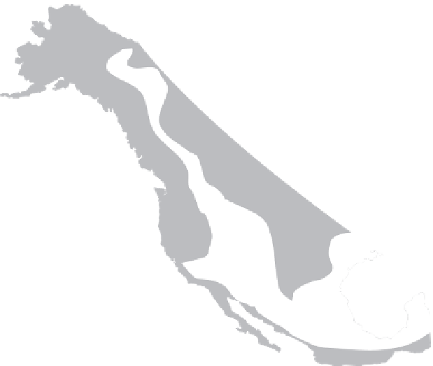
Colorado Plateau
Denali Fault
Mojave-Sonara Megashear
San Andreas Fault
Queen Charlotte Fault
Tintina Fault
Strike-slip faults
Phanerozoic accreted crust
Disrupted craton
Craton
&3
')
060
6$)
4&)
7)
7)
')
4&)
Approx. line of section
6$)
&3
1000
0
060
km
(b)
Coast/Cascade
Ranges
Sierra Nevada
batholith
Basin - Range
Rocky
Mountains
Former
Extension
+
Epeirogenesis
Tilting
Subduction
Figure 24.8
General structure (a) of the western North American cordillera, with (b) a representative West-East cross-section.
Source: In part after Howell (1995)
of the basin-range structures of Nevada and Utah. The San
Andreas transform fault system and coastal mountains of
southern California are the product of oblique subduction
and crustal extension. Subduction of the northern Pacific
place is also raising the
stratovolcanoes of Mount St Helens, Mount Hood, Mount
Rainier, etc., with the highest peak in the contiguous
states, Mount Whitney (4,418 m), in the latter.
American cordillera are high enough to support
mountain icefields intermittently throughout their length,
including equatorial Ecuador, where the snowline rises to
4·6 km. Substantial valley glaciation with tidewater
glaciers down to sea level occurs polewards of 50
in
southern Chile and Alaska. The St Elias and Juneau
icefields of Alaska are among the largest outside polar
circles (
Plate 24.6
).
Rapid sea-floor spreading and sub-
duction (5-10 cm a
-1
in the Andes and 5-7 cm a
-1
in
North America) promote continuing active uplift (10-70
cm ka
-1
in the Andes and 30-60 cm ka
-1
in western North
America).
250 km wide Aleutian and
Alaska ranges and coastal mountains of Alaska and British
Columbia. The highest coastal cordillera reach 4·0-6·2 km
and include Mount Denali (6194 m), the highest peak in
North America. Lower cordilleran systems lie inland,
separated by narrow coast-parallel intermontane basins.
Farther south, coastal ranges from Washington to
southern California rarely reach 3 km high, but the more
extensive Cascade and Sierra Nevada ranges rise 3·5-4·4
km east of the Willamette and Sacramento-San Joaquin
basins (
Plate 24.5
).
The former includes the ice-capped
This is accompanied by seismo-volcanic