Geoscience Reference
In-Depth Information
Subsurface remote sensing techniques
NEW DEVELOPMENTS
Where quarrying, core recovery or excavation (
Plate 23.5
)
are unsuitable or insufficient, subsurface lithology and
structure can be assessed by several remote sensing techniques - usually over large areas and terranes. Of these,
seismic studies are the oldest and general principles of earthquake seismology are set out in the box on p.209. Seismic
studies also use shocks triggered artificially by explosive, compressed air or mechanical means to construct vertical
and 3-D subsurface profiles. Seismic reflection is a major tool of sequence stratigraphers, capturing 2-D profiles of
subsurface boundaries (seismic reflectors) between facies of different material composition and hence seismic velocity
(
Figure 23.2
).
Although it can be enhanced to provide 3-D images, the development of seismic tomography, a geological
version of medical CATSCAN techniques, may become more useful in this regard. Ground-penetrating radar (GPR) is
another innovation providing images of near-surface structures, currently of value to Quaternary studies, archaeology
- and forensic investigations of human burials!
Seismic, GPR and drilling programmes can complement each other, and various recent and new wireline logging
techniques extend information available from boreholes beyond recovered core samples. Sensors return continuous
geochemical, textural and structural data along the borehole to the surface. Among these,
neutron logsdifferentiate
between compact, low-porosity sediments (low values), porous limestones and sandstones (medium values) and
hydrocarbon reservoir rocks (high values). Spectral gamma ray logsdetect radioactive and heavy metal constituents
and electrical resistivity provides another means of measuring rock density. Local inclination or dip of facies
boundaries and internal formational or diagenetic structures are visible in recovered cores but their significance for
regional dip, and thus sequence stratigraphy, utilizes dip meter logs.
eruption events, adding ash and cinder facies to the
sequence. Offshore, the Carboniferous rocks of northern
England traced the transition from shallow, carbonate-
rich subtropical shelf seas (limestone) to an encroaching
delta (sandstone and shales) and eventual vegetation of
emergent parts of the delta (coal deposits). Sequence
stratigraphy is a key diagnostic and predictive tool -
recognized in hydrocarbon exploration industries, where
it is best developed.
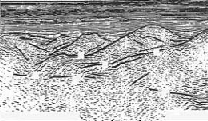
Shot 2900
3000
3100
3200
4
4
6
6
8
8
?
D
10
10
D
12
12
14
14
0
5
Vertical exaggeration 1.5:1
km
16
16
Atlantic passive continental margin, showing extended conti-
nental crust. Syn-rift/proto-oceanic tiltblocks are capped by syn-
rift (Mesozoic) sediments and bounded by low-angle
detachment faults (D). The whole is draped by post-rift marine
sediment.
Source: Pickup et al. (1996)
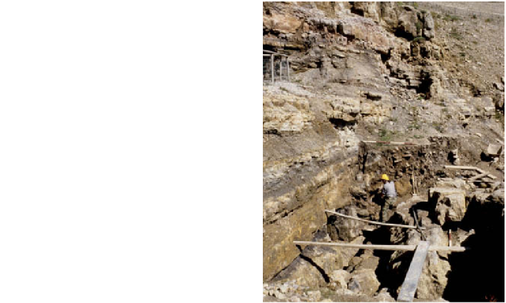
European Bronze Age copper mine, on the Great Orme,
Llandudno, north Wales.
Photo: Ken Addison