Geoscience Reference
In-Depth Information
cuttings), and can be laterally extensive but usually quite
limited vertically. Drilling recovers subsurface rock or ice
core samples for laboratory analysis and enables the
remote sensing of facies boundaries and rock properties
in situ
by wireline logging (see box, p. 565) and seismic
reflection studies. Clearly, recovery and analysis of
materials provide the most accurate subsurface picture
down the line of the core but very little of the lateral
continuity or otherwise of the rocks and structures. The
international Ocean Drilling Programme (ODP) and
various continental rock and ice-sheet drilling projects
obtain several kilometres of continuous core recovery,
providing evidence on which our understanding of
ocean-atmosphere-ice sheet interactions and climate
change depend. Expense limits deep drilling (10
2-4
m) to
widely dispersed networks with inevitable difficulties
of correlation, mostly for scientific research or commer-
cial exploration of known or suspected aquifers, mineral
and hydrocarbon reservoirs. Civil engineering utilises
densely spaced coring (usually only 10
1-2
m deep) for
concrete piling of foundations or geotechnical assessment
of difficult ground around construction projects. Access
to such core data of near-surface sediments can be of
particular value to terrestrial Quaternary studies and
geoarchaeology and augments hand-
augering
or light-
weight powered coring techniques employed widely in
shallow, soft-sediment environments such as lakes, peat
bogs,etc.(
Plate 23.2a
and
b
)
.
Most rocks are
minerogenic
and inorganic by nature,
even where fossils provide a
biogenic
component set in a
detrital matrix. Exceptions include the progressively
lithified organic sequence from peat through lignite to
coal - and most limestones, although they may be
reprecipitated biochemical solution products of once
living colonies of corals, shells or bones rather than
recognizable plant or animal remains. We refer to the
smallest individual layer or
stratum
of sediment as a
bed
,
the boundary between each bed as a
bedding plane
and
sometimes detect even finer layers or
laminae
within
beds, especially in fine-grained materials. These units
usually range between 10
1-3
cm and 10
0-1
mm thick
respectively. This descriptive subdivision alone may satisfy
engineering geomorphologists, concerned primarily with
the impact of bedding planes and other internal struc-
tures or
discontinuities
on rock-mass strength. However,
fluvial hydrologists or glaciologists analyse contents in
more detail, with grain-size analysis, palaeocurrent and
other sedimentary structures and particle geochemistry
enabling reconstruction of flow velocities, directions and
mechanisms, regional bedrock sources and palaeo-climate
(see
Table 23.1)
For these purposes, thick accumula-
(a)
(b)
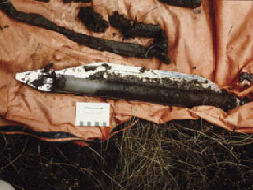
glacigenic sediments, Pen-y-bryn, Caernarfon, north-west
Wales. (b) A Russian hand-corer with cores recovered from
the base of a Cumbrian mire, showing dark, organic-rich peat
separated by grey minerogenic sediment attributed to a final
Late Devensian cold surge (Loch Lomond stadial or European
Younger Dryas stage) c.12 kyr
BP
.
Photos: Ken Addison
tions and long sequences of rocks are divisible into
manageable
packets
or
facies
which makes their study
and interpretation easier.
Facies analysis and sequence
stratigraphy
Each facies shares common internal characteristics
(which may change laterally), formative processes and
environmental origins. It is distinguished from adjacent
facies by recognizable boundaries indicative of
conform-
able
or continuous sequences, with negligible (typically