Geoscience Reference
In-Depth Information
0.125 62.5
125
0.25
250
0.50
0
°C
0
°C
0
°C
Latitudinal regions
Altitudinal belts
500
1.00
Nival
Polar
1.5°C
1.5°C
1000
2.00
Dry
tundra
Moist
tundra
Wet
tundra
Rain
tundra
Subpolar
Alpine
3°C
3°C
2000
4.00
Dry
scrub
Moist
forest
Wet
forest
Rain
forest
Desert
Subalpine
Boreal
6°C
6°C
4000
8.00
Desert
scrub
Cool
temperate
Moist
forest
Wet
forest
Rain
forest
Desert
Steppe
Montane
12°C
12°C
16.00
8000
Lower
montane
Premontane
Warm
temperate
Subtropical
Thorn
wood-
land
Dry
forest
Moist
forest
Wet
forest
Rain
forest
Desert
scrub
Desert
24°C
24°C
32.00
Rain
forest
Desert
scrub
Thorn
woodland
Dry
forest
Moist
forest
Wet
forest
Very dry
forest
Desert
Tropical
62.5
125
250
500
1000
2000
1.00
4000
8000
32.00
16.00
8.00
4.00
2.00
0.50
0.25
0.125
Semiparched
Superarid
Perarid
Arid
Semiarid
Subhumid
Humid
Perhumid
Superhumid
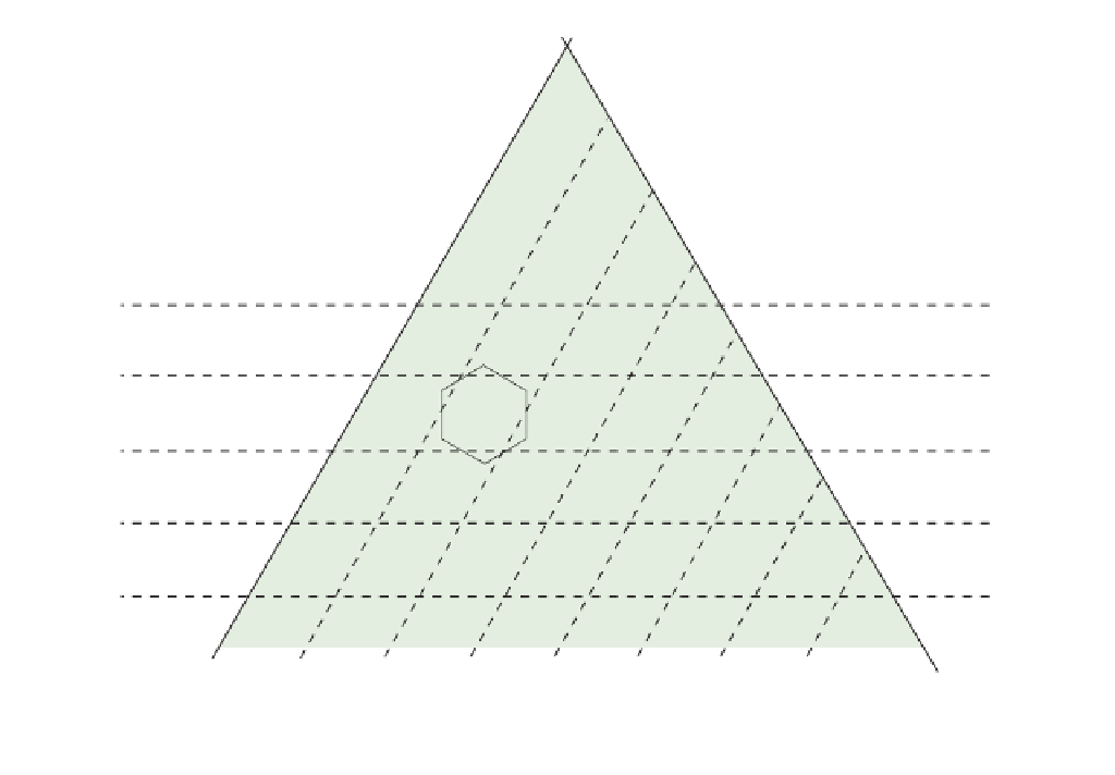
Figure 20.5
Holdridge system for classifying world vegetation based on climate and geographical location.
Source: After Holdridge (1984)
:\IHYJ[PJ
)VYLHS
;\UKYH
([SHU[PJ
-VYLZ[
[\UKYH
Precipitation
Evaporation
;HPNH
*VU[PULU[HS
4P_LK
MVYLZ[
+Y`
ZJY\I
:[LWWL
4LKP[LYYHULHU
:^HTW
MVYLZ[
+LJPK\V\Z
MVYLZ[
+LZLY[
ZJY\I
:JY\I
Figure 20.6
Holdridge diagram of vegetation
types in Europe based on water
availability.
Source: After WCMC (1992)
Evaporation
Precipitation