Geoscience Reference
In-Depth Information
forces are able to move water containing ions to the
surface, where intense evaporation results in salt deposi-
tion. This is the so-called 'wick effect'. Where salt crusts
are formed, they usually consist of a finely comminuted
salt dust which can be blown up into the atmosphere,
eventually to come down by gravity or in rain to influence
soil formation in surrounding areas. Salinity is also
added to the soil surface by the addition of fertilizers to
the irrigation water, some of which will not be taken up
by plants. Salty soils will also occur where saline ground
water results from the presence of salt deposits in the
geological column.
Saline soils described above are classified as
solonchaks
,
though they have also been called
white alkali soils
in the
United States. They contain sulphates and chlorides of
sodium and potassium, though magnesium and nitrate
ions may also occur. They show white salt efflorescence
at the surface but usually no change in structure down
the profile. They are low in humus, reflecting the low
productivity of natural vegetation, and the low input of
plant residues. The pH values are in the range 8·0 to 8·5
but go no higher because of the high concentration of
neutral soluble salts. Soil-forming processes are inhibited
and profile development is minimal.
If a situation arises whereby salts no longer accumulate
at the surface, there will be far-reaching changes in the soil
profile. For example, if the water table falls, or rainfall
increases, rainfall may wash the salts through the profile.
If the salts are mainly calcium salts, soil formation will go
in the direction of xerosols or chernozems. However, if the
content exchangeable sodium exceeds 15 per cent 0n the
colloids, sodium carbonate will be formed, as carbonate
(CO
3
-
) and bicarbonate (HCO
3
-
) anions are continually
being produced by the respiration of plant roots and soil
organisms. Sodium carbonate gives the soil a pH of 9·0,
an unstable and deflocculated structure and a dark-
coloured, often black, soil surface due to dispersed humic
particles in the alkali conditions. Dispersed clay particles
are readily washed down into the subsoil, where they
form a clay pan, which dries into hard columnar units.
These distinctive soils are called
solonetz
,or
black alkali
soils
in the United States (
Plate 18.19
).
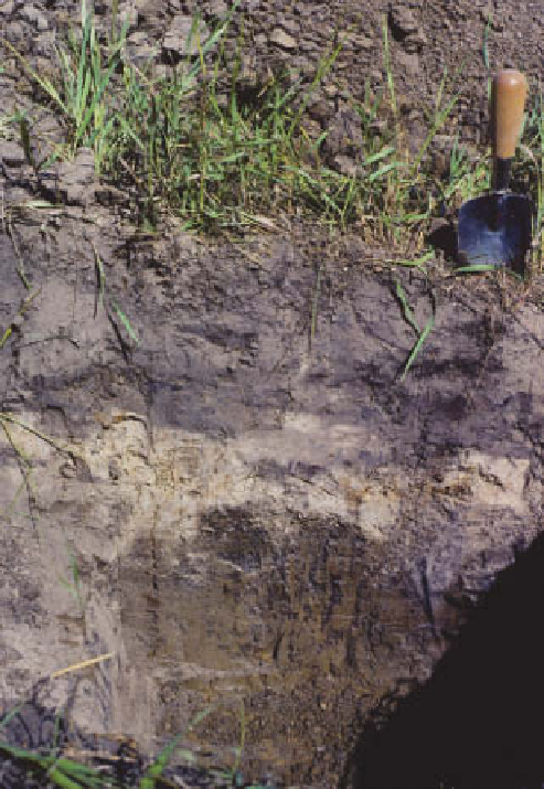
As the leaching of salt continues, and more clay and
organic matter moves into the clay pan, a pale (E) horizon
forms above a spectacular columnar structure, with the
top of the columns having a white coating of amorphous
silica. Soils with this striking profile are known as
solodized
solonetz
(
Plate 18.20
).
Further leaching removes significant
amounts of sodium, the B horizon structure is lost. The
resulting soil has a loose, coarse-textured, acidic A horizon
over a hard, compact B horizon with a neutral-to-acidic
Canadian prairies, showing pale eluvial horizon, and subsoil
clay pan with incipient columnar structure.
Photo: Ken Atkinson
pH. This soil is the
solodic planosol
, previously called
solod
. This model of soil evolution from solonchak to
solodic planosol is shown in
Figure 18.14
.
Soils affected by salinity and alkalinity have low fertility.
High concentrations of soluble salts are harmful to plants.
The salinity of the soil is measured by the
electrical
conductivity
(EC) of a saturation paste, or of water
extracted from a soil which has just been saturated with
water (the
saturation extract
). The units are millisiemens
The alkalinity of soil is measured by three properties: the
pH, the
exchangeable sodium percentage
and the
sodium
adsorption ratio
(the ratio of sodium ions to the square
root of the calcium plus magnesium ions):
Na
+
SAR =
—-————
(Ca
2+
+ Mg
2+
)