Geoscience Reference
In-Depth Information
Coastal realignment
NEW DEVELOPMENTS
Coastal realignment can mean one of two things. In a general sense, any natural or human action on the coastline
is likely to alter, or realign, the precise 3-D position of the land-sea boundary. It is also used specifically to describe
the process of managed retreat - or rolling easement, as it is called in the eastern United States - as the least
expensive, most sustainable response to rising sea levels. It accepts the inevitability of inundation but attempts to
harness natural defence measures. Managed retreat may be a preferred option in areas of marginal economic value
but also attracts interest in industrialized regions as part of integrated coastal cell management schemes. Muddy
estuaries such as the Severn and Thames estuaries in Britain, Chesapeake and Delaware Bays in the United States
and throughout south-east Asia, for example, support salt marshes or mangroves on the landward side of mud flats
in the intertidal zone. They provide some of the most effective wave-breaking systems and highly diverse habitats
which migrate in response to sea-level change. Landward migration of these biogeomorphic systems occurs if
sediment accretion rates match sea-level rise. If sea-level rise exceeds accretion rates, the marsh front can erode
and lead to its eventual removal. However, their particular value as natural, sustainable and inexpensive sea defences
is often compromised by hard defences at their inland margin, giving rise to
coastal squeeze. The marsh eventually
disappears, squeezed between rising sea level and inner sea walls, if migration is prevented (
Plate 17.11
).
Moreover,
the barrier may induce the formation of a sedimentary ramp from the disappearing marsh or beach, which eases the
path of tidal and storm surges (
Plate 17.12
).
Experimental removal of hard defences, in areas of low economic
vulnerability, permit inundation but conserve the marsh. This creates opportunities to assess the effectiveness of
managed retreat as part of a comprehensive coastal defence system and may lead to alternative, low-impact uses.
Loss of habitat, for example, in areas where hard defences and tidal barriers remove internationally important breeding
or migratory feeding grounds of shellfish and seabirds can be replaced on a deliberate quid pro quo basis. In this
way, the Royal Society for the Protection of Birds (RSPB) announced a £12 M scheme in 2007 to re-flood part of
Wallasea Island in the Thames estuary through tidal exchange, returning it to a state similar to that last seen in the
seventeenth century. Sea water will be allowed in through culverts, without removing the seawalls, re-creating 320
ha of mudflats, 160 ha of salt marsh, 125 ha of salt meadow and 96 ha of shallow salt water and 64 ha of brackish-
water lagoons.
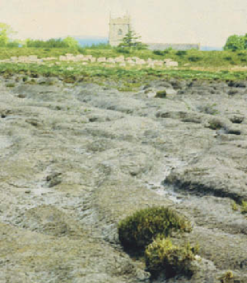
seawall protecting the Wentlooge Level, south-east Wales;
the medieval church of Peterstone Wentlooge can be seen
across the seawall. Managed retreat is probably precluded
here by coastal infrastructure development which includes the
LG electronics plant, a new industrial park and active landfill
site.
Photo: Ken Addison