Geoscience Reference
In-Depth Information
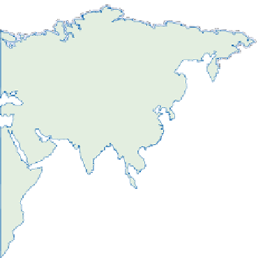
LONGITUDE
60°
120°
180°
120°
60°
0°
80°
80°
Arctic Ocean
D
D
D
60°
60°
D
D
D
40°
40°
D
D
D
D
D
D
Atlantic
Ocean
R
R
D
D
20°
20°
R
D
R
Pacific
Ocean
R
R
R
D
D
R
0°
0°
R
R
D
D
R
20°
20°
R
Indian
Ocean
R
D
40°
40°
D
0
5000
60°
60°
km
Southern Ocean
60°
120°
180°
120°
60°
0°
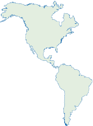
TECTONIC COASTS
COASTAL MORPHOLOGY
Leading edge (convergent margin)
Trailing edge (passive margin)
Epicontinental sea coasts
Mountains
Headlands and bays
Coastal plains
D
R
Major delta
Coral reefs
Ice-bound (permanent/seasonal)
Source: After Inman and Nordstrom (1971)
water at the river mouth. Sediments enter denser (saline)
water via a plume from which they are rained out, or less
dense water (where high suspended loads raise fresh-
water density) via sea-bed density currents. Where river
and seawater densities are very similar, a
Gilbert-type
delta
forms by successive overlap of
sediment packets
, providing
a classic bottom-set-fore-set-top-set sequence (
Figure
beyond the delta front. The main channel meanders,
between natural levées, through older channel and over-
bank sediments. A delta plain, reminiscent of the
flood plain, develops to either side. Levées are breached
periodically, often in river flood or storm conditions,
and the resultant crevasse splays and distributary
channels form new delta lobes (see
Chapter 14).
Earth's
largest modern delta (that of the Amazon) covers
500,000 km
2
; the Ganges-Brahmaputra (Bangladesh),
Mekong (Vietnam) and Yangtze (China) each exceed
50,000 km
2
.
Deltas
Deltas develop by
progradation
or seaward extension of
river flood plains. Most large deltas are located on trailing-
edge or other passive-margin coasts, fed by trunk rivers
draining substantial continental areas - often sedimentary
or cratonic basins. Many have foundations 10
5-7
a old but
their modern configuration is essentially mid to late
Holocene in age, postdating the Flandrian transgression.
Low Quaternary sea levels drew flood plains across the
continental shelf, delivering sediment closer to shelf slope
margins and the ultimate oceanic sink. Transgression
trimmed flood plains back towards the modern coast,
where tides, waves and the necessary large fluvial sediment
flux all help to shape the delta landsystem (
Figure 17.13
).
The delta front advances by sediment deposition as
bed- and suspended-load particles enter lower-velocity