Geoscience Reference
In-Depth Information
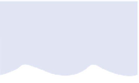
COASTAL ZONE
Material in transit
BACKSHORE
FORESHORE
INSHORE
OFFSHORE
MORPHOLOGY
Cliff or barrier
Berm edge
HWM
Coastal
plain
Beach face
MSL
LWM
Trough
Longshore bar
SWASH
ZONE
SURF ZONE
BREAKER ZONE
WAVE
ENVIRONMENT
NEARSHORE ZONE
Figure 17.1
The coastal zone and its component morphology, tide and wave environments, including high-water mark (HWM),
mean sea level (MSL) and low-water mark (LWM).
water back into the sea. This
surf zone
, between the
breaking waves and the point of maximum
run-up
, is one
of turbulent water exchange and maximum geomorphic
activity associated with wave-generated currents. Spilling
waves dissipate their energy forwards in the surf zone,
whereas surging waves are reflected back into following
waves. Forward and return pulses -
swash
and
backwash
- move at right-angles to the shore in orthogonal waves,
generating shore-normal (right-angle) currents. Some of
the swash percolates beach sand and gravel, reducing the
immediate backwash volume but leading to later seepage
on the receding tide. The swash from refracted waves
moves diagonally onshore but backwash returns normally
down the maximum slope, resulting in a net
longshore
current
. Swash and backwash interfere with each other to
some extent and hold water up ahead of the breaking line.
Scarcely visible
edge waves
are established at right angles
to breaking waves through their incessant mass shoreward
transfer of water, escaping laterally rather than directly as
backwash. Water level is increased or
set up
when edge
wave and incoming wave crests coincide, and lowered or
set down
when they are out of phase.
Beach cusps
form
where set-up and set-down cause incoming waves to break
farther from (deeper) and nearer (shallower) the shore
respectively, creating a sinuous breaking line. All three
processes establish lateral currents in the surf zone
which eventually drain seaward as powerful
rip currents
,
completing a cellular pattern of water movement (
Figure
longshore drift
of sediment. Rip currents cut and
accelerate through rip channels in soft sediments before
dissipating at nearshore
rip heads
.
Riphead
Onshore waves
Breaker zone
Longshore currents
Beach
Tidal action and currents
Although breaking wave systems appear to dominate
coastal geomorphology, tidal waves and tsunamis (see
Chapter 11)
are also important in a number of respects.
Geomorphic activity is concentrated in the surf zone,
whose maximum vertical and lateral extent is a product
of tidal range as well as of wave height (
Figure 17.4
).
They
work together in storm surges which, although relatively
infrequent, may have major geomorphic impacts (
Figure
level is about +0·6 m in Britain and up to +1·5 m on
tropical cyclone coasts. Hurricane Hugo created a storm
surge of +11 m on the South Carolina coast of the
United States in 1989. Distinctions between
micro-
,
meso-
and
macro
tidal ranges (see below and
Chapter 11)
demonstrate the persistent impact of tidal waves in