Geoscience Reference
In-Depth Information
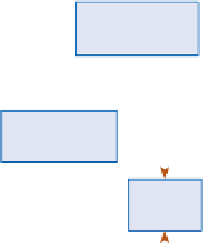
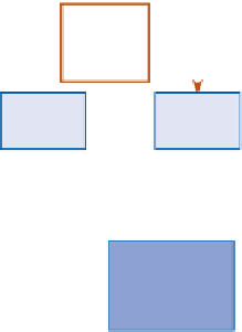
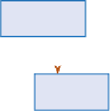
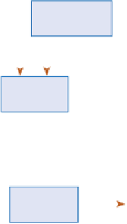
Bank material
% silt/clay
Meander
wavelength
—
—
+
Valley slope
—
+
—
—
Width-depth
ratio
+
Sinuosity
Width
+
+
—
+
+
+
+
Bedform
amplitude
Depth
Channel
slope
—
+
—
—
—
+
+
—
—
+
—
+
+
—
Power per
unit length
Power per
unit area
Sediment
transport rate
Friction
factor
Velocity
+
+
—
—
+
—
+
Bedform
wavelength
Bankfull
discharge
Bed
material
size
+
+
Source: After Richards (1982)
factors
and
system states
. The research question now
becomes 'How does the system work in terms of inputs
and outputs from other systems, in terms of links between
the component parts of the system, and in terms of
changes in the flows and storage of matter over time?' The
essence of the systems paradigm is to study the interaction
of system components, their integration and their
relationships with external variables.
The degree to which systems thinking should be
adopted by physical geographers has been a matter of
debate; some advocate the rigorous adoption of General
Systems Principles (e.g. Chorley and Kennedy 1971),
whilst others regard systems thinking as a useful
framework which should not preclude the appreciation of
an historical element in the study of landscapes (e.g.
Richards 1982). The adoption of systems thinking
emphasizes the spatial interactions which take place
between parts of the landscape. For example, in Upper
Wharfedale processes of weathering, mass movement and
erosion on hill slopes interact with the ability of the river
Wharfe and its tributaries to move sediment down the
river channel. In other words, hill-slope processes interact
with fluvial processes. However, these interactions take
time before there will be a perfect balance between the
processes and the landforms. If there was a consistent
PHYSICAL GEOGRAPHY
Earlier it was observed that the progress of physical
geography has been achieved by a series of definable
stages. Each stage will have a dominant
paradigm
or
model
which influences the thinking of researchers and helps to
organize and systematize the data which they collect. Thus
fieldworkers in the early and mid-twentieth century in
Upper Wharfedale would have mapped the form and
heights of the high-level watersheds which separate
Wharfedale from Airedale to the south-west and from
Wensleydale to the north-east. The prevailing
paradigm
would have been that of the
cycle of erosion
model of W.
M. Davis. The research questions might have been 'Are
there erosion surfaces on the higher ground which
indicate erosion cycles which operated in the past?' and
'How quickly is the present land surface being denuded
by weathering, slope processes and river action?'
We have seen how in the late twentieth century the
adoption of a systems perspective in physical geography
led to the revolutionary new paradigm of 'systems
thinking' with its emphasis on transfers of energy and
matter both within the system and also with the system's
external environment. The emphasis here is on
processes,