Geoscience Reference
In-Depth Information
thread to their lives and are aware of threats to coastline
integrity through rising sea level, and to water quality
through pollution. Globally, we view oceans increasingly
as a potential source of food and minerals as we outgrow
terrestrial resources. Geographers now recognize the need
to understand our oceans better and this chapter sets out
the more important dynamic characteristics of the global
ocean.
suture orogen is now widely dispersed, from the southern
Appalachians, through southern Britain and north central
Europe to the Urals and north-eastern Asia. Pangaea's
Carboniferous-Permian-Triassic rocks reflect global
palaeo-climates with a major south-polar ice sheet,
subtropical deserts and equatorial swamp deltas and
shallow, carbonate-rich seas (
Figure 11.1
).
Rifting began
in parts of Pangaea just as other parts were sutured
together,
c
. 255 Ma ago in the Permian period, as a
precursor of the eventual break-up. The early Mesozoic
global Panthalassic Ocean covered an entire hemisphere
off Pangaea's west coast, with a major arm, the Tethys
Ocean, partially enclosed by its more indented east coast.
Sea-floor spreading opened new oceans at their expense.
American plates moved west as the Atlantic opened,
consuming the Panthalassic/Pacific Ocean faster than it
was spreading. Their respective ocean basin areas have
changed by +160 per cent and -35 per cent during
the Cenozoic (
Figure 11.2
).
Cordilleran systems on the
American Pacific coasts have incorporated older,
Palaeozoic subduction terranes and North America has
now overrun much of the Pacific mid-ocean ridge. The
BASINS
After Pangaea: the formation of modern
oceans
Modern ocean-continent distributions reflect the break-
up of Pangaea, which coalesced as Earth's most recent
supercontinent in the late Palaeozoic,
c
. 290 Ma ago. It
survived for
c
. 100 Ma before restless tectonic stresses
rifted it apart again. Rocks common to its now separated
parts reveal that it embraced
Gondwana
, centred between
the south pole and the equator, and the northern
hemisphere mass of
Laurussia
. Their
Hercynian
collision-
61Ma
60°N
30°N
R
0°
30°s
P
E
E
E
E
P
P
P
P
E
P
Tethys Ocean
60°s
120°E
180°
120°W
60°W
0°
Present
60°N
30°N
0°
30°s
Permo-Carboniferous
Ice sheet
Carboniferous
coal measures
Caledonian
Orogen
P, Petroleum deposits E, Evaporite deposits (rock salt, gypsums)
60°s
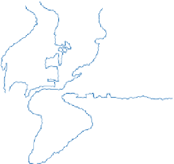
Figure 11.1
Reconstruction of the supercontinent Pangaea
collision orogen, formed on closure of the Iapetus Ocean as
Pangaea began to coalesce, and the concentration of coal and
evaporite deposits along the equator. Petroleum deposits
were also formed there later, in the Cretaceous.
Source: In part after Keary and Vine (1996)
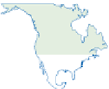
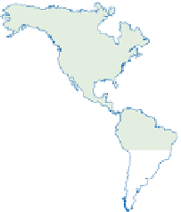
120°E
180°
120°W
60°W
0°
Cenozoic, showing shrinkage of the Pacific basin, largely at
the expense of the spreading Atlantic basin. Arrows show
directions and relative rates of plate motion.
Source: Open University (1992)