Geoscience Reference
In-Depth Information
been cold before the storm approaches, temperatures may
rise slightly. This is due to cloud and wind stirring up the
cold air. If it has been warm, temperatures may fall,
because the sun will no longer be shining. Suddenly the
temperature starts to rise, perhaps by several degrees
within a few hours. It will then remain fairly stable until
the arrival of the cold air in the rear of the cyclone. The
fall in temperature is usually more sudden than the earlier
rise; a fall of up to 10
followed by altostratus, then nimbostratus clouds, by
which time rain will be falling. In general, the atmosphere
is fairly stable at a warm front, but some convection does
occur in the middle levels, producing areas of heavier
precipitation.
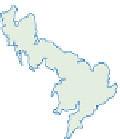
Figure 7.11
shows an example of the rainfall
patterns associated with a warm front and a cold front.
The slope of the cold front is much steeper, at about
1 in 50. Weather activity at the cold front can be much
more intense than at the warm front. If the warm air is
unstable, the effect of uplift at the front may generate
thunderstorms and even tornadoes. The line of deep cloud
distinct band. The cold air descending with the heavy rain
can intensify the effect of the fall in temperature.
When the air in the warm sector between the fronts is
rising, cloud development near the fronts follows the
pattern described above; this is known as an
ana-front
(from the Greek word meaning 'up'). Just ahead of the
cold front, and at about 1 km above the surface, strong
winds develop in the warm sector. This warm, moist flow
rises over the warm front and turns south-eastward ahead
of it as it merges with the mid-tropospheric flow (
Figure
conveys large quantities of energy polewards. Convective
instability may be produced between this lower, warm,
moist air and the cooler, drier air aloft, to produce the
typical banded precipitation of the warm front (
Figure
C within a few minutes is not
unknown, though more frequently the frontal zone may
extend in width for 100-200 km and produce a fall in
temperature of a few degrees.
The sudden change of temperature clearly indicates a
change of air mass. The separation surface or zone
between air of different origins is call a
front
. Where warm
air is replacing cold air we have a warm front, and where
cold air is replacing warm air we have a cold front. The
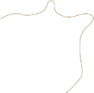
typical cloud structure along the fronts is shown in
Figure
produced by divergence in the upper atmosphere. That is
why the clouds do not follow the frontal surface as closely
as one might expect.
The warm front slopes at a low gradient of about 1 in
300, which means that the first clouds associated with the
front can be seen long before the surface front is near.
Cirrus clouds are the first indicators of the approach of
the front, followed by a sequence of gradual thickening
and lowering of the cloud base. Cirrostratus clouds are
(a)
(b)
Moderate
Moderate
Slight
Very slight
1024
Figure 7.11
Rainfall radar for 23.00 UTC, 21 February 2007, and corresponding surface pressure map for 00.00 UTC, 22
February 2007. Note the lack of correspondence between surface frontal positions and moderate intensity rainfall.
Redrawn from Meteorological Office website