Geoscience Reference
In-Depth Information
(a)
10
20
20
10
10
20
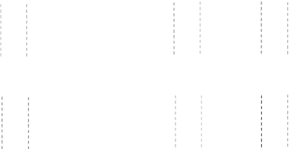
Figure 6.11
The development of
divergence and convergence in
(a) horizontal and (b) vertical
movements in the atmosphere.
Divergence
Diffluence
Strong
Divergence
Indeterminate
20
20
10
10
20
10
Convergence
Confluence
Strong
Convergence
Indeterminate
(b)
Convergence
Divergence
Mean level of
non-divergence
(about 600 hPa)
A S C E N T
S U B S I D E N C E
Convergence
Divergence
Surface
Low
Pressure
High
Pressure
Various other factors disrupt this pattern further, for
Earth is not at rest, nor uniform, as we have so far assumed.
It rotates. Its surface is highly variable; it has oceans and
continents; it consists of a mosaic of mountains and
plains. Moreover, the inputs of solar radiation vary
considerably both on a seasonal and on a daily basis.
been called - solar radiation is converted into heat. The
air expands and rises and flows out towards the poles.
Cool, dense air from the poles returns to replace it. We
can readily demonstrate the pattern of circulation by
heating a dish of water at its centre. Hot water bubbles up
above the heat source and flows across the surface to the
cold 'polar' areas. At depth the flow is reversed. So long as
this unequal heating is continued, the cellular flow is
maintained.
In reality, however, the pattern is found to be more
complex, for, instead of flowing directly to the poles at
high altitudes, the warm air from the equator gradually
cools and sinks, owing to radiational cooling. Most of it
reaches the surface between about 20
Effect of Earth's rotation
The rotation of Earth causes the winds to be deflected
from the simple pattern just identified. The deflection is
towards the right in the northern hemisphere and towards
the left in the southern hemisphere. Instead of a direct
meridional flow, the Coriolis force produces a surface
flow similar to that shown in
Figure 6.1
.
This is not the only effect of Earth's rotation. Air
moving towards the poles from the tropics forms a series
of irregular eddies, embedded within the generally
westerly flow. These can be seen on the satellite photo-
graphs as spiralling cloud patterns, similar to the patterns
latitude,
and this subsiding air gives rise to zones of high pressure
at the tropics - the subtropical high-pressure belts. As the
descending air reaches the surface it diverges, some
returning towards the equator to complete the cellular
circulation of the tropics, the remainder flowing pole-
wards (
Figure 6.12
).
and 30