Geoscience Reference
In-Depth Information
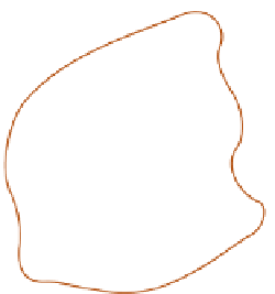
(a)
(b)
0
10
km
Figure 5.13
Correlation patterns associated with (a) air mass storms and (b) low-pressure centres, during May-September in
Illinois.
Source: After Huff and Shipp (1969)
a particular period in one area, it would tend to be low
beyond 100 km. Over the short term these differences may
be considerable, but in the long term we would expect
them to balance out.
Within any climatic region, the relation between
rainfall and altitude is generally quite consistent. In most
cases, precipitation increases with increasing altitude, even
in relatively arid areas. At the Grand Canyon, for example,
average annual precipitation increases from less than 250
mm on the canyon floor at 760 m to 400 mm on the
southern rim of the canyon at 2,100 m. On the forested
northern rim, 2,600 m above sea level, rainfall totals over
600 mm.
Nevertheless, the progressive increase in rainfall with
altitude does not always extend to the summits of the
mountains. The Sierra Nevada in California is no wetter
on the summit than it is 1,200 m lower (
Figure 5.16
).
In
the subtropical trade wind belt over Hawaii the peaks of
Mauna Loa and Mauna Kea receive far less rain (380 mm)
than the windward slopes, where maxima between 1,000
m and 1,300 m amount to about 7,500 mm yr
-1
. It is
also apparent that the relationship between altitude
and precipitation varies from one part of the world to
another. In the tropics much of the precipitation is
produced by warm clouds whose upper limit is only 3,000
m above the ground; thus the effect of altitude is subdued
(
Figure 5.16a
)
and the maximum may even be close to
Surface modifications of precipitation
So far we have considered rainfall variability over essen-
tially flat terrain. Few areas of the world are extensively
flat, however, and surface irregularities interfere with
atmospheric processes to give even more complex spatial
patterns of variation in rainfall. Even relatively small hills
can have a marked effect. The importance of surface
topography on precipitation is indicated at a general scale
for the British Isles in
Figure 5.14
.
As can be seen, the
general pattern of rainfall is appreciably modified by the
Welsh and Scottish mountains. They give rise to higher
totals on the western slopes, and a marked rain shadow
on the east. The effect of altitude in the leeward areas is
less apparent. For example, the Cairngorms in north-east
Scotland do not stand out as areas of higher rainfall in
Figure 5.14
,
despite their height, because the prevailing
winds have lost much of their moisture by the time the
eastern side of the country is reached.