Geoscience Reference
In-Depth Information
(a)
metres
800
2000
4000
6200
(b)
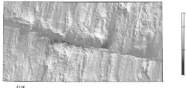
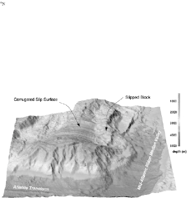
Figure 9.19.
(a) Bathymetry of a 90 km × 180 km area on the Mid-Atlantic Ridge,
showing the Atlantis transform fault. The deepest parts of the transform are at, and
between, the two ridge-transform intersections (RTI) at 30
◦
N, 42
◦
W and 30
◦
05
N,
42
◦
40
W. The fracture zone continues as a clear linear feature trending 103
◦
both on
the African plate and on the North American plate. The seabed away from the ridge
axis is characterized by linear abyssal hills. These volcanic hills are usually a few
hundred metres high, parallel the ridge and extend up to the fracture zone. Three
topographic highs exhibit the corrugations suggestive of detachment surfaces: at
30
◦
10
N, 42
◦
05
W, the active inside corner north of the transform fault; at 30
◦
15
N,
43
◦
00
W, an 8-Ma-old fossil inside corner north of the transform fault; and at
29
◦
55
N, 42
◦
30
W,afossil inside corner south of the transform fault. Colour version
Plate 20(a). (From Blackman
et al
., Origin of extensional core complexes: evidence
from the Mid-Atlantic Ridge at Atlantis Fracture Zone,
J. Geophys. Res.
,
103
,
21 315-33, 1998. Copyright 1998 American Geophysical Union. Reprinted by
permission of American Geophysical Union.) (b) A three-dimensional shaded relief
image of the active inside corner shown in (a). The image is viewed from the south
and illuminated from the northwest. The area is 30 km east to west and 35 km north
to south. The corrugated surface dips at ∼10
◦
towards the median valley. The slipped
block is volcanic. Colour version Plate 20(b). (Reprinted with permission from
Nature
(Cann
et al
.,
Nature
, 385, 329-32). Copyright 1997 Macmillan Magazines Ltd.)