Geoscience Reference
In-Depth Information
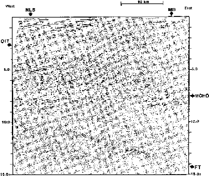
Figure 4.52.
The British Institutions Reflection Profiling Syndicate (BIRPS), which started
data acquisition in 1981, collected a large amount of data on the continental shelf around
the British Isles. The short segment of unmigrated 30-fold data shown here (taken from
the WINCH profile) is from an east-west line off the north coast of Scotland. NLB, North
Lewis Basin; MB, Minch Basin; OIT, Outer Isles Thrust; and FT, Flannan Thrust. The Outer
Isles Thrust can be traced from the surface down into the lower crust with a dip of
approximately 25
◦
. The basins are Mesozoic half-grabens. The North Lewis Basin and
other basins apparently formed as a result of extension associated with the opening of the
North Atlantic. The structure of the basins was controlled by the fabric of the existing
Caledonian basement, in this instance the Outer Isles Thrust. The Moho on this section is
a very clear reflector at 8-9 s two-way time (depth about 27 km). The Flannan Thrust cuts
the Moho and extends into the upper mantle as a very clear reflector. Further data from
this area are shown in Figs. 10.25 and 10.26. (From Brewer
et al
.(1983).)
Problems
1. How would you distinguish between Love waves and Rayleigh waves if you were given
an earthquake record from a WWSSN station?
2. What is the wavelength of a surface wave with a period of (a) 10 s, (b) 100 s and (c) 200 s?
Comment on the use of surface waves in resolving small-scale lateral inhomogeneities
in the crust and mantle.
3. How much greater is a nuclear-explosion body-wave amplitude likely to be than an
earthquake body-wave amplitude if both waves have the same
M
S
value and are recorded
at the same distance?
4. (a) Which types of seismic wave can propagate in an unbounded solid medium?