Geoscience Reference
In-Depth Information
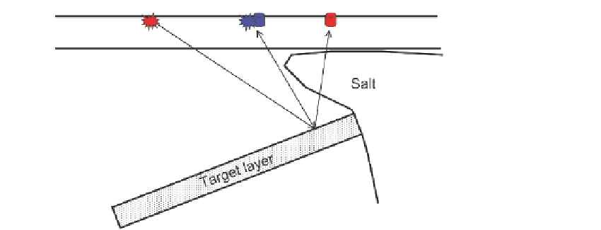
Fig. 2.10
Strike shooting over a salt dome. Dip shooting (in the plane of the section) would see
complex ray-paths due to the presence of the salt, while strike shooting (in and out of the page)
would be largely unaffected by the salt.
currents, it may be difficult for the boat to travel in or against the direction of the current
and maintain good control over the cables and the required shot point spacing, leaving
little choice on shooting direction.
Modern seismic boats are designed to tow large numbers and lengths of receiver
cables through the water while remaining acoustically quiet so as to avoid unwanted
noise on the recorded data. Special expansion joints are used in the cables to ensure
that the cables themselves do not transmit noise along their length. The streamers have
neutral buoyancy in the water so that they are easy to tow at a fixed depth (usually
between 3 and 11 m depending on the seismic resolution required and the sea state)
below the sea-surface. This avoids near-surface noise problems caused by the action of
waves. In the past cables were filled with oil-based fluids to give them neutral buoyancy,
but solid streamers are becoming more common as they are both environmentally
friendlier and acoustically quieter. Special winged devices called 'birds' are attached to
the cable to keep it at the required depth. These are remotely controlled by an on-board
computer and permit changes in receiver depth (for instance in response to changing
weather conditions) during operations without any need to bring the cables back on
board.
To be able to shoot and process data accurately from a 3-D survey the boats have
sophisticated navigation systems. During operations the boat and cables are subject
to currents and winds, which will often cause the cables to be pushed away from the
simple line-astern configuration, a situation known as 'feathering'
(fig. 2.11)
. This
means that the positions of shots and receivers must be continuously recorded, and
this information needs to be stored together with the trace data. Today the entire world
has 24 h satellite coverage that allows the use of GPS satellite positioning of the
vessel to an accuracy within a metre. The streamers have a series of compasses and
transducers along their length. The transducers send out signals whose travel times