Geoscience Reference
In-Depth Information
with base-of-slope and inner basin-floor systems.
Such unique characteristics can be attributed to
controls imposed by: 1) the slope gradient; 2) the
slope profile and topography evolution; 3) the
proximity to and the type of delivery system(s) (e.g.
Reading & Richards, 1994); and 4) the common
association with erosional bypass and/or connec-
tion to exit channel features (e.g. Mayall & Stewart,
2001; McHargue, 2001; Booth
et al
., 2002; Sinclair &
Tomasso, 2002; Prather, 2003; Smith, 2004). In
consort, this commonly results in a complex
reservoir architecture and stratigraphy of slope
turbidite infill.
Sediment delivery to the deep-water basins may
be via deltas, shelf and upper slope gravitational
sediment failure, or storm and shelfal current
re-suspension of marine sediments (e.g. Piper &
Normark, 2009 and references therein). Deltaic
delivery systems may range from large and muddy
to small and sandy deltas (Reading & Richards,
1994); the latter are more common in tectonically
active basins and along immature passive mar-
gins, where shallow marine to shelfal sand is fed
directly to upper slope canyons. Hyperpycnal
flows generated from rivers-in-flood have recently
been recognised as an important mechanism to
generate prolonged or sustained sediment gravity
flows (Mulder
et al
., 2003; Bhattacharya &
MacEachern, 2009; Piper & Normark, 2009).
Upslope gravitational collapse and mass wasting
is another important flow-initiation process, pro-
ducing ensuing surge-like gravity flows (Piper &
(A)
(B)
2
°
E
3
°
E
4
°
E
5
°
E
6
°
E
7
°
E
N
50 km
2
°
E
3
°
E
High at Base Cretaceous
4
°
E
5
°
E
6
°
E
7
°
E
Late Cretaceous fault
Late Jurassic fault
High at Base Te rtiary
Inversion high
Late Tr iassic to Mid Jurassic fault
Edge of basalt
(C)
Central
Møre Basin
Vigra
High
Ormen
Lange Dome
Slørebotn
Subbasin
NW
SE
0
5
10
15
20
0
5
10
15
20
25
30
25
30
50 km
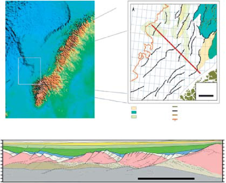
Fig. 1.
(A) Location of Møre Basin offshore Mid-Norway. (B) Structural elements map of the Møre Basin with location of
the Ormen Lange subbasin. (C) Interpreted section across the eastern Møre Basin (modified from Osmundsen & Ebbing,
2008). Basement is represented by various shades of purple, brown, grey and pink. Palaeozoic to Jurassic sediments are
shown in pale and blue colours. Cretaceous is marked by clear (lower to middle) and pale green (upper), whereas the
Palaeogene and Neogene are shown in orange-yellow and grey, respectively. The orange marks the Palaeocene. Line loca-
tion is shown on the structural elements map (B) in red.
Search WWH ::

Custom Search