Geoscience Reference
In-Depth Information
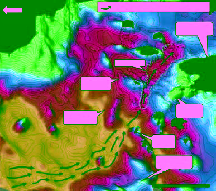
Interpreted bottom current direction
N
Lindesnes
Ridge
Channel
Ekofisk
Field
Eldfisk
Field
Albuskjell
Field
Salt
diapir
Josephine
High
20 km
Fig. 19.
Seismic map showing the channel extent relative to the main tectonic and halokinetic topographic features.
A SSE-moving bottom current is interpreted to have flowed alongside the eastern margin of the Josephine High and then
through a narrow topographically defined passage near the Albuskjell Field. The current became more confined and was
forced to flow up-slope where it began to erode the channel. The lack of interpretation over certain areas is due to the low
quality seismic image. The isopleth contour lines are every 20 ms
-1
.
Lüning
et al
., 1998) and preservation, i.e. dissolu-
tion of pelagic forms.
This bottom current could be generated by a
series of distinct forces, such as differences in
temperatures and salinity (thermohaline currents),
wind shear stress (wind-driven currents) or
gravitation of the moon (deep-water tidal currents).
However, the available data do not allow the
nature of the current to be specified, apart from
indicating that it was topographically confined
and its activity was long-lived. Nonetheless, a
thermohaline circulation of water masses driven
by density variations in response to changes in
water temperature and salinity is the most
favoured mechanism since this tends to generate
regular, long-lived bottom current systems
(cf. Surlyk & Lykke-Andersen, 2007).
Late Cretaceous marine circulation in
the Chalk Sea
The Late Cretaceous epeiric chalk sea was charac-
terised by strong bottom currents that swept the sea
floor creating deep channels, moats and sediment
drifts in many areas (Lykke-Andersen & Surlyk,
2004; Surlyk & Lykke-Andersen, 2007; Esmerode
et al
., 2007, 2008; Surlyk
et al
., 2008; Esmerode &
Surlyk, 2009). These morphogenic features are sim-
ilar to those formed along the modern continental
margins where bottom currents flow parallel to the
slope bathymetric contours (Viana & Rebesco,
2007; Rebesco & Camerlenghi, 2008).
Bathymetric interpretations of the chalk sea vary
quite considerably. Distefano
et al
. (1980) suggested
water depths ranging from 150 m to 600 m for
Search WWH ::

Custom Search