Geoscience Reference
In-Depth Information
Reworked Carnian-Norian palynomorphs into Upper
Jurassic Fulmar Fm. shoreface facies
Barren, terminal splay and playa deposits of Scythian to Early
Anisian character
Fulmar Fm.
Grounded
Smith
Bank Fm.
pod
Skagerrak Fm.
Zechstein
halite
Channel confined,
biogenic traces
Grounded
Smith
Bank Fm.
pod
Terminal splay, barren
Smith
Bank Fm.
Playa
100 m
c. 15 km
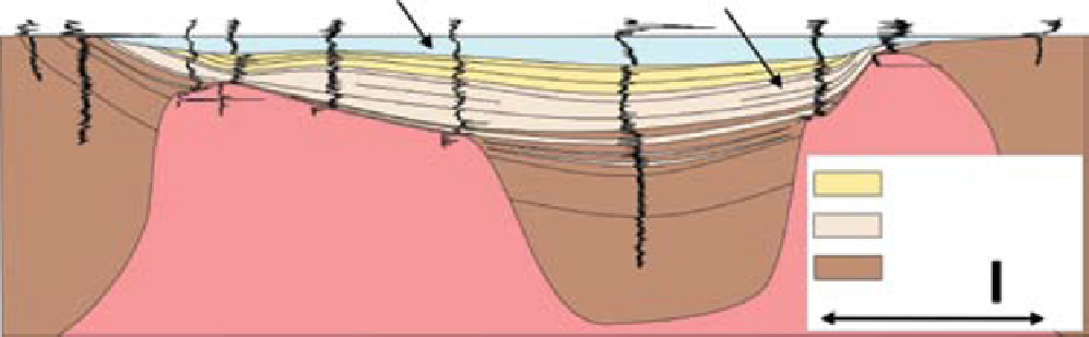
Fig. 17.
Smith Bank and Skagerrak formation well log correlation across a single interpod on the UK Western Platform in
the area of the Gannet and Guillemot Fields. The section runs through wells UK 21/24-2, UK 21/29b-7, UK 21/30-8, UK
21/25-2, UK 21/25-3, UK 21/30-3, UK 21/30-6A, UK 21/30-19, UK 21/30-4 and UK 21/30-13S1. Interpod Triassic facies are
composed of distal terminal splay facies. The overlying Fulmar Formation records renewed salt withdrawal from interpod
regions during Late Jurassic extension. These open marine deposits commonly contain reworked Late Triassic palynomorphs
and erosively overlie in-situ Lower and Middle Triassic deposits. The restricted distribution of these open marine
sandstones is likewise interpreted to be a product of the same preservational bias as the underlying Skagerrak Formation,
rather than a reflection of syn-depositional bathymetry or geomorphology.
Formation sandstones (Fig. 17). The overlying
Fulmar Formation locally contains reworked
Triassic palynomorphs of Ladinian to Rhaetic age,
indicating erosion of a former cover of upper
Triassic and reworking into the interpod areas
during Jurassic halokinesis. It is likely therefore
that there had formerly been a relatively complete
Triassic section, the lower parts of which survived
erosion due to on-going salt withdrawal and sub-
sidence below stratigraphic base level. Both uncon-
fined Triassic sheetflood and upper Jurassic open
marine deposits are now preserved in a shared
geometry inconsistent with their original deposi-
tional setting and the Triassic section records the
oldest and deepest parts of the Skagerrak Formation
succession which subsided into long-term preser-
vation space below the erosion level of regional
Middle Jurassic denudation.
Across the central North Sea the transition from
the mudstone-dominated Early Triassic fill to the
widespread dispersal of Middle and Late Triassic
fluvial sediments in basin-wide sheets is probably
indicative of a fundamental change in the extent
to which salt controlled the routing of sediment
into and across the central North Sea. The mud-
prone Smith Bank Formation, with its highly vari-
able thickness and minibasin geometry, probably
records sediment loading and dissolution during
initial fluvial sediment supply into the desiccated
Zechstein basin, which created a tortuous basin
floor topography that ephemeral river systems in
an arid climate were unable to breach or traverse.
Basin filling occurred by distal muddy floodwaters
infiltrating and ponding in the evolving minibasin
topography. Whilst thickness variations in the
overlying Skagerrak Formation succession occur,
there is little evidence of the fluvial facies being
significantly confined or steered on a basin scale
by the underlying salt and palaeocurrent data
derived from borehole images and oriented cores
show little influence from the underlying salt
structures (cf. Prochnow
et al
., 2006; Matthews
et al
., 2007). This pattern of deposition can be
taken as indicative of a setting where the fluvial
profile was generally located substantially above
the level of salt deformation, which was responding
passively to sediment loading and subdued fault
movement and sediment supply was generally
capable of quickly infilling and smoothing any
surface expression of movement at depth.
CLIMATIC CONTROLS
Through the Permian and Triassic Western Europe
was located within the equatorial arid and semi-arid
climatic belts (Hounslow & Ruffell, 2006; Feist-
Burkhardt
et al
., 2008). The vast continental interior
of Pangaea created extreme continentality, with a
pronounced monsoonal seasonality and dry winters
Search WWH ::

Custom Search