Geoscience Reference
In-Depth Information
Franklin 29/5b-6Z
Elgin
22/30c-13
Glenelg 29/4d-4
GR
Depth (m)
30 60 90
120
5230
Bioturbation
Parallel lamin.
Current ripples
Cross-bed
Depth (m)
30 60 90 120
GR
5235
FS
5240
5280
5245
5285
FS
Depth (m)
30 60 90 120
GR
5250
5290
5255
5295
5685
5260
5300
5690
FS
5265
5695
5305
5270
MFS
5700
5310
FS
5275
5705
5315
5280
5710
5320
Erosive
truncation
5285
5715
5325
5290
5720
5330
Elgin
Turbidite sandstone
Shoreface sandstone
Lower shoreface sst
Offshore shale
29/4d-4
5725
29/4d
To tal
22/30c-13
5730
Glenelg
Franklin
5 km
29/5b-6Z
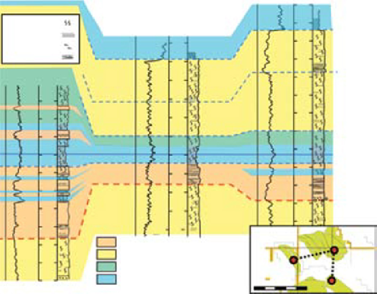
Fig. 18.
Correlation between cored intervals of Glenelg, Elgin and Franklin fields showing the preservation of parallel
laminated sandstone of turbidite origin overlying a surface of truncation with local pebble lag development (Franklin Field
well 29/5b-6). GR: Gamma Ray log.
characteristics related to the presence of
Rhaxella
sponge spicule material (see later section on
diagenesis and influence of
Rhaxella
spicule).
The Franklin B Sandstone represents the thick-
est and most important reservoir in the field. The
Upper Franklin B Sandstone was deposited dur-
ing a long term retrogradational phase while the
lower part of the Franklin B Sandstone was depos-
ited during the preceding progradational phase
(Fig. 17). However, the erosive unconformity
surface at the base of the Franklin C Sandstone
has produced pronounced thickness variations of
the Franklin B Sandstone. Passing from south to
north across the structure, the uppermost interval
of the Franklin B Sandstone is erosionally thinned
from 90 m to only 10 m thick. In addition, this
thinning takes place in the same direction in
which the sandstone was initially thickening (as
indicated by thickness trends of parasequences in
the erosional remnants, see Fig. 17). Thus, a pref-
erential depocentre was effectively inverted into a
preferential site of erosion. The variably eroded
interval is also notable for containing large quantities
of
Rhaxella
sponge spicule debris, which has
resulted in high secondary porosity content.
Lasocki
et al
. (1997) noted that the lag and over-
lying parallel laminated sandstone were “open
to several possible interpretations with major con-
sequences on reservoir correlation and trends”.
The sandstone overlying the erosive surface was
initially interpreted as a mass flow deposit
(Lasocki
et al
., 1997). Subsequently, it was reinter-
preted with the base of the unit taken to represent
a planar regression surface at which an unknown
amount of erosion had taken place. The overlying
structureless to parallel laminated sands above
the erosional surface were interpreted to have been
deposited in a high-energy foreshore or shoreface
environment. Later, Jeremiah & Nicholson (1999)
placed the same interval of the 29/5b-6 well in the
context of adjacent wells such as the 22/30b-11
well of Shearwater Field. In the 22/30b-11 well, a
thick interval of parallel laminated sandstones
were interpreted as turbiditic mass flow sandstone
deposits developed above a major erosion surface
identified as SJU310. Several other wells with
Search WWH ::

Custom Search