Geoscience Reference
In-Depth Information
(A)
> 100 ms TWT
> 200 ms TWT
N
> 300 ms TWT
> 400 ms TWT
HP
> 500 ms TWT
60°
> 600 ms TWT
ESP
VG
SB
> 700 ms TWT
SB
ÅG
EB
FFZ
FFZ
F
FFZ
F
F
F
F
F
F
F
FFZ
FFZ
F
F
FF
F
F
F
F
F
L
L
L
FB
L
LFB
L
F
F
B
NDB
CG
RFH
100 km
56°
0°
4°
8°
(B)
SW
NE
1,00
2,00
50 km
(C)
SW
NE
0,00
30 km
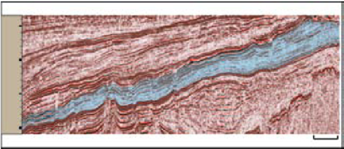
Fig. 8.
(A) Time-thickness map of the Late Cretaceous Chalk Group. (B) Seismic section with the chalk sequences marked
in blue. Notice the increase in thickness towards north-east. For location of the seismic line, see A. (C) The seismic line is
flattened at base of Chalk Group. Note the truncation of the lower Cretaceous strata, indicated by yellow arrows.


Search WWH ::

Custom Search