Geoscience Reference
In-Depth Information
24
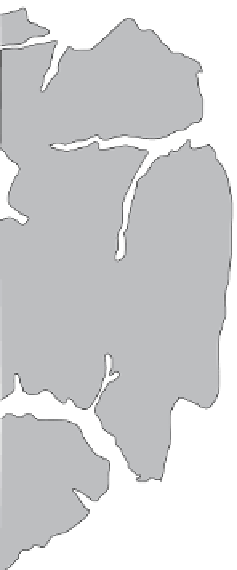
22˚
20˚
Wollaston
Forland
SVALBARD
Clavering Ø
EGL
JAN
MAYEN
73°
73
ICELAND
1000 km
26
U.K.
Hold with Hope
Ymer Ø
Geographical Society Ø
Tr aill Ø
72°
72°
Fig. 4
Scoresby
Land
Wegener
Halvø
50 km
Faults
Te rtiary intrusives
Te rtiary extrusives
Cretaceous
Jameson Land
Jurassic
Milne
Land
Liverpool
Land
Tr iassic
Permian
Carboniferous
Devonian
Pre Devonian
26°
24°
22°
Fig. 1.
Geological map of East Greenland. Small map shows present-day North Atlantic (referred to as the Norwegian-
Greenland Sea in the text) and discussed areas of the East Greenland (EGL) and the Norwegian Continental Shelf (NCS).


Search WWH ::

Custom Search