Geoscience Reference
In-Depth Information
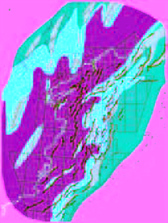
(A)
(B)
3°E
6°E
9°E
3°E
6°E
9°E
N
N
68°E
68°E
68°E
68°E
66°E
66°E
66°E
66°E
64°E
64°E
64°E
64°E
62°E
62°E
62°E
62°E
3°E
6°E
9°E
3°E
6°E
9°E
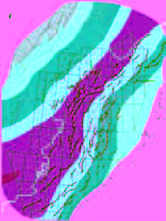
(C)
(D)
3°E
6°E
9°E
3°E
6°E
9°E
N
N
68°E
68°E
68°E
68°E
66°E
66°E
66°E
66°E
64°E
64°E
64°E
64°E
62°E
62°E
62°E
62°E
3°E
6°E
9°E
3°E
6°E
9°E
LEGEND
Hinterland/exposed
Lacustrine
Fluvial/oodplain
Shelfal
Delta-plain
Deeper shelf
Deltaic-marginal marine
Fig. 5.
Early and Middle Jurassic palaeogeographies of the Norwegian-Greenland Sea rift-system. (A) Hettangian to
Sinemurian (Åre Formation) fluvial plain; (B) Pliensbachian (uppermost Åre Formation & Tilje Formations) embayment;
(C) Toarcian to Aalenian (Ror-Tofte and ile Formations) shelfal strait; and (D) Bajocian to Bathonian (Not-Garn Formations)
rift-structured shelfal strait. Note however that the basin changed back and forth between an unstructured (as shown in B
and C) to a moderately structured (as shown in D) basin during the Toarcian to Bathonian. Modified from Nøttvedt
et al
.


Search WWH ::

Custom Search