Geoscience Reference
In-Depth Information
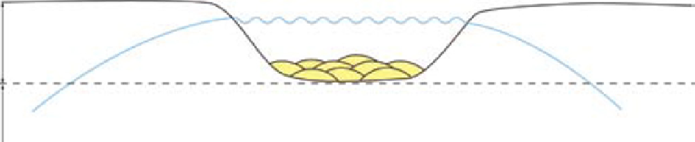
Floodplain (upper limit to temporary deposition)
Temporary storage:
real time accommodation
Lower limit to erosion = upper limit to permanent deposition
Permanent storage:
net accommodation
Groundwater level
Fig. 13.
Definition of real-time accommodation (sensu Blum & Törnqvist, 2000) and net accumulation space. Real-time
accommodation is the accumulation space in which sediment is initially stored but can be removed again at time scales
less that 10
3
yr. The upper boundary of real-time accommodation is defined by the upper limit to accumulation (equilib-
rium floodplain heights) and the lower boundary of real-time accommodation is defined by the lower limit to erosion
(maximum depth of channel incision). Net accommodation (
sensu
Blum & Törnqvist, 2000) is defined as the accumulation
space that lies below the maximum depth of channel incision (upper boundary) and is related to the lower limit to erosion.
The lower boundary of real-time accommodation, equivalent to the upper boundary of net accommodation (lower limit to
erosion), is chosen as the stratigraphic reference level or base level.
the volume of space that can be filled. Filling of
the available accumulation space is governed by
the relationship between stream power and sedi-
ment load and how this changes in response to the
lower limit to erosion. From this it follows that
sediment initially stored in the accumulation
space can be removed again and it is therefore
defined as real-time accommodation (cf. Blum &
Törnqvist, 2000; Fig. 13) estimated here to operate
at time scales of 10
3
yr to 10
4
yr. Increases and
decreases in real-time accumulation space at
process scale occur in response to (1) changes in
the lower limit to erosion and (2) changes in
discharge regimes and sediment supply which
control equilibrium floodplain heights (upper
limits to accumulation). Consequently, the upper
boundary of real-time accommodation is defined
by the upper limit to accumulation (equilibrium
floodplain heights) and the lower boundary of
real-time accommodation is defined by the lower
limit to erosion (maximum depth of channel inci-
sion). Note that the upper limit to accumulation
varies in elevation due to local build-up of levees
of up to several metres. Consequently, the upper
boundary of real-time accommodation varies tran-
siently in height between levees and floodplain
surfaces.
It is important to note that deposition and pres-
ervation operate at different rates and time scales.
Preservation in the stratigraphic record occurs
when the deposits become buried below possible
depths of channel incision and removal, that is,
below the lower boundary of real-time accommo-
dation. Preservation space, or net accommodation
(a term proposed by Blum & Törnqvist, 2000),
therefore, lies below the maximum depth of chan-
nel incision (upper boundary) and is related to the
lower limit of erosion (Fig. 13). It is also related to
the time scale of observation and to aerial space
because the maximum depth of incision will vary
through time as a result of base level changes sug-
gesting different fluvial response times following
a perturbation (such as, for example, a single
channel incision and relocation or the relocation
of an entire channel belt).
Fluvial base level
The use of sea-level (upper boundary of potential
accommodation) as stratigraphic reference level
(or base level) has no practical meaning in subaerial
environments far away from the contemporaneous
shoreline such as the Statfjord Group in the Statfjord
Field. Fluvial systems are only influenced by
marine base level at their distal terminations and
therefore issues associated with changes in relative
sea-level are not discussed.
The equilibrium profile of graded rivers (Mackin,
1948) is used commonly as base level in sequence
stratigraphic studies of fluvial and alluvial plain
successions. Mackin (1948) defined the graded
profile as a conceptual surface which marks equi-
librium with prevailing discharge and channel
characteristics. At time scales of 1 yr to 10
5
yr, stud-
ies of Quaternary deposits have indicated that
upstream controls (for example, water discharge
and sediment influx) cause 1 m to 10 m of profile
adjustment within the same drainage (Goodbred &
Kuehl, 2000; Blum & Törnqvist, 2000; Schumm
et al
., 2000). However, it is problematic to recognise
Search WWH ::

Custom Search