Geoscience Reference
In-Depth Information
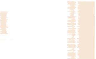
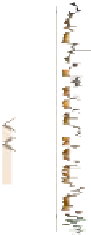
Snorre
North
South
N
34/4-2
34/7-3
33/12-2
34/10-13
34/10-30
34/10-J-4 H
UNITS
Visund
RHOB
RHOB
RHOB
GR
RHOB
AM
RHOB
NPHI
GR
GR
Gullfaks
GR
NPHI
NPHI
GR
Statfjord
NPHI
NPHI
Gullfaks South
0
1
0
Rimfaks
km
DESCRIPTION
USG
- Sandstone rich interval
?
- Dominated by
floodplain deposits
?
LSG
- Well log TA
- Stacked meandering
channel deposits
ULF2
ULF1
- Dominated by
floodplain deposits
- Stacked meandering
channel deposits,
high sst. %
- Tr ansition from
braided to meandering
channel deposits
MLF
- Braided ch. deposits
- Reduced sst. %
- Increased separation
between sandstones
- Multilateral channel
deposits
LLF
- Multistorey, multilateral
channel deposits
- Very high sst. %
ALKE
Fig. 16.
Allostratigraphic correlation within the Lunde Formation and the Stafjord Group in the Tampen Spur area,
northern North Sea, from the Snorre Field in the north to the Rimfaks Field in the south. LLF = lower Lunde Formation,
MLF = middle Lunde Formation, ULF = upper Lunde Formation, LSF = lower Statfjord Group (Raude Formation),
USG = upper Statfjord Group (Eiriksson Formation) and AM = Amundsen Formation.


Search WWH ::

Custom Search