Geoscience Reference
In-Depth Information
N
6300 Å Airglow depletions from Ascension Island
1000
900
800
E
W
700
600
500
7 Feb 1981 21:20 LT
400
21
0
1
2
3
Magnetic longitude (
8
West)
S
(a)
(b)
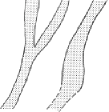
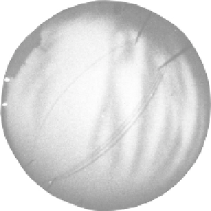
Figure 6.15a
(a) All-sky photograph at 6300
Å
taken from Ascension Island at 2120 LT
on February 7, 1981. (b) Linear and bifurcated airglow features recorded in the all-sky
camera photograph after mapping to the equatorial geomagnetic plane. [After Mendillo
and Tyler (1983). Reproduced with permission of the American Geophysical Union.]
these structures take on the vertical wedge-like shapes shown in Fig. 4.7b. These
wedges tilt to the west as noted in Chapter 4 and seem to give definitive proof of
the wedge versus bubble geometry for the equatorial depletions. Observations
of the equatorial anomaly from the TIMED satellite often display dark bands.
Comparison with an airglow camera on the ground as in Fig. 6.15b shows that
they are of CEIS origin.
These depletion regions owe their origin to an equatorial phenomenon but
in turn create the seed for very strong local off-equatorial F-region instabilities.
This stems from their associated east-west horizontal density gradients. Such
gradients are unstable to the generalized Rayleigh-Taylor instability discussed in
Chapter 4. To first order, gravity does not play a role, since
g
is perpendicular
to
∇
n
for a horizontal gradient. For
g
=
0, the criterion for instability discussed
in Chapter 4 is
E
×
(
B
)
·∇
n
>
0
(6.15a)
where
E
=
E
+
U
×
B
(6.15b)
is the electric field that would be measured in the neutral frame of reference,
while
E
and
U
are the electric field and neutral wind vectors in the earth-fixed
frame, respectively. As noted earlier,
B
is unchanged in such a transformation if
U
c
, the speed of light. At midlatitudes it is usually the case that
|
U
×
B
|
>
|
E
|
.
For
E
=
0, (6.15a) implies that an eastward wind is destabilizing to a westward

Search WWH ::

Custom Search