Geoscience Reference
In-Depth Information
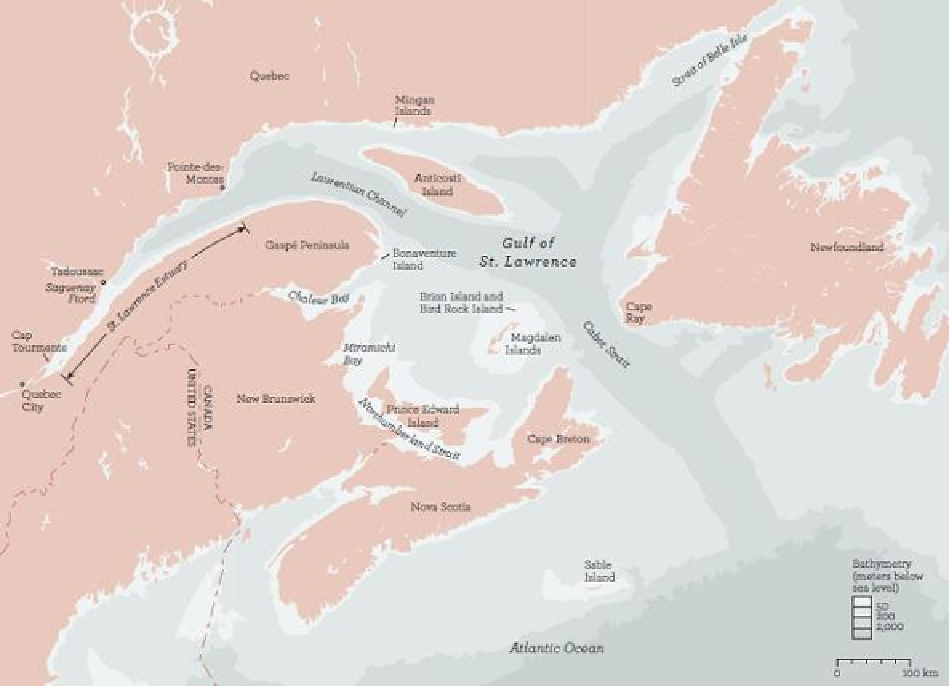
The St. Lawrence Estuary and Gulf of St. Lawrence
Two features set the Gulf of St. Lawrence apart from other semi-enclosed seas, such as the Baltic Sea and
the Black Sea. Normally an estuary discharges its freshwater flow directly into the deep waters of the contin-
ental shelf, but in the Gulf of St. Lawrence the freshwater is discharged into a shallower basin, a drowned low-
land formed during the Carboniferous period, when the major channels that crisscross it were first eroded. The
second distinguishing feature is the enormous size of the drainage basin that feeds it, primarily through the St.
Lawrence River. This source of freshwater includes the Great Lakes and, at 226,000 square kilometers (87,000
square miles), is nine times as large as the surface area of the gulf itself. Its massive freshwater flow is greater
than the runoff from the entire east coast of the United States, from Canada to southern Florida, and its influen-
ce is felt as far away as the Scotian Shelf and the Gulf of Maine, a distance of 1,300 kilometers (800 miles),
where catches of some twelve species of fish landed from the Gulf of Maine and Georges Bank can be correl-
ated with river outflows.
But salt water—shelf water—enters the mouth of the great river through the Laurentian Channel, which cuts
diagonally across the gulf. This channel exceeds depths of 350 meters (1,150 feet) along most of its length,
dipping to more than 500 meters (1,640 feet) near the Cabot Strait and extending 250 kilometers (155 miles)
across the continental shelf. Despite the enormous flush of freshwater from the St. Lawrence River, it is swal-
lowed up and overwhelmed by the tidally driven Gaspé Current, which entrains more than a hundred times the
volume of the river runoff in its counterclockwise circulation of the gulf.