Geoscience Reference
In-Depth Information
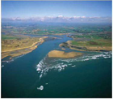
FIG
89.
The Torridge-Taw Estuary. (Copyright Dae Sasitorn & Adrian Warren/
www.lastrefuge.co.uk)
Several large rivers run through this Landscape. In the centre, the valleys of the
Torridge (
b2
) and the Taw (
b3
) wind northwards from headwaters on the northern mar-
gin of Dartmoor, draining the west and northeast before emptying into Bideford Bay
(
b9
), also sometimes called Barnstaple Bay) on the north coast (Fig. 89).
It is the rest of the drainage of this Area that is so remarkable, as has been pointed
out in the introduction to this chapter. It is extraordinary that the other main rivers - the
Tamar (
b1
) and the Exe (
b4
) - join the sea along the south coast, yet drain southerly
even quite close to the north coast. This has been taken to suggest that the Southwest
Region has been tilted southwards, causing the southerly-flowing rivers to erode their
headwaters, thus extending their areas to the north.
Landscape erosion of the Variscan folds has picked out sandstone layers to form
ridges and valleys, trending west to east, and this is very clearly shown on the slope
map (Fig. 84). The southern coastal section of this Landscape runs from Bude (
b5
) to
Hartland Point (
b6
), and is almost entirely formed of flat-topped cliffs displaying beau-
tiful zigzag folds, clearly visible at Hartland Quay, 3 km south of the Point (Fig. 90).