Geoscience Reference
In-Depth Information
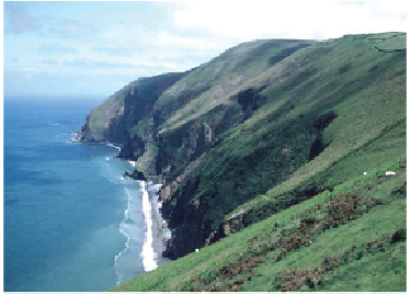
FIG
85.
The typical hog's-back cliff profile of the Devonian bedrock of Exmoor, looking
eastwards towards Foreland Point (Fig. 81,
a5
). (Copyright Landform Slides - Ken Gard-
ner)
The section of the coast from the Culbone Hills (
a4
) to Foreland Point (
a5
) il-
lustrates well the contrast between the actively eroding coast and inland areas with an
older ground surface. Whereas the coastal slope is wooded and steep, descending from
a line of hills some 350 m high, the other side of the hillcrest contains the sinuous and
well-developed valley of the East Lyn, flowing parallel to the coast. The mature inland
landscape has been transected by vigorous coastal processes of erosion (Fig. 86).
The long coastal section from Foreland Point (
a5
) to Combe Martin (
a7
), Ilfra-
combe and round the corner to Morte Point (
a8
) and Baggy Point (
a10
) contains classic
examples of different forms of cliff profiles seen in southwest England. The 'corner' at
Morte Point (
a8
) marks a change from bedding-parallel erosion along the north-facing
coastline to the east, to erosion that cuts across the folding and layering of the bedrock
to the south. This has produced the distinctive finger headlands of Morte and Baggy
Points.
Hog's-back
cliffs have small, steep cliffs near sea level that pass upwards into a
distinct slope inclined at 30-40 degrees towards the sea (Fig. 87). These slopes become
gentler towards their summits and may continue into an inland-facing slope, producing
a convex-upward, hog's-back form. Contrasting
flat-topped
cliffs are present at Morte
Point, further west (
a8
), and result from horizontal or poorly layered bedrock that pro-
duces a near-vertical cliff with a flat top.
Bevelled
cliffs appear to form when rising sea
level meets terrain which already has a smooth convex-upwards slope profile.