Geoscience Reference
In-Depth Information
FIG
72.
The Tamar and Brunel Bridges, between Plymouth (Devon), to the right, and
Saltash (Cornwall). (Copyright Dae Sasitorn & Adrian Warren/www.lastrefuge.co.uk)
The headlands from Bolt Tail (
b2
) to Start Point (
b5
) are made of some of the
most highly altered and probably oldest bedrock in Devon, although the age of their
deposition as sediments is not known. They have been changed locally to mica-rich
and hornblende-rich schists that must have been altered (metamorphosed) several kilo-
metres below the surface, before being pushed upwards during the Variscan mountain-
building event. The local resistance of these schists to erosion has led to a particularly
intricate pattern of small but sharp headlands and tight small bays. The slope map (Fig.
78) reveals a strong east-west orientation of slopes in this area that must be a reflec-
tion of folding in the bedrock. Three separate coast platforms, the highest at about 7 m
above present sea level, are very clear at Sharpers Head (
b4
). Each platform represents
an episode in the retreat and relative lowering of the sea before the latest Flandrian rise.
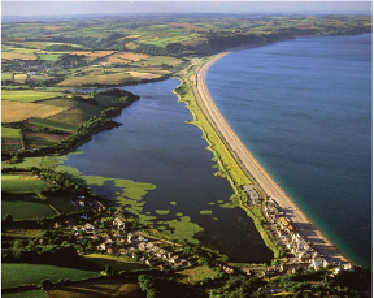
FIG
73.
Slapton Sands (Fig. 66,
b7
). (Copyright Dae Sasitorn & Adrian Warren/
www.lastrefuge.co.uk)