Geoscience Reference
In-Depth Information
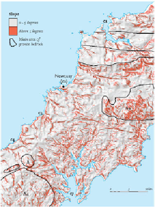
FIG
61.
Slope map of the eastern part of West Cornwall. The main granite bedrock areas
are outlined and important boundaries in the Devonian bedrock indicate the direction of
the Variscan folding. Note the circular china-clay workings that are visible in the St Aus-
tell granite (
A5
).
FIG
62.
Complex landscape of the North Cornwall coast, looking eastwards from Crant-
ock Beach, over the Pentire Ridge towards Newquay (Fig. 52,
c2
) and Watergate Bay.
(Copyright Dae Sasitorn & Adrian Warren/ www.lastrefuge.co.uk)