Geoscience Reference
In-Depth Information
to the west, and the Lake District of England and the mountains of Wales to the east.
The ice extended across the mouth of the Bristol Channel, well clear of the present
north Cornwall coastline, before leaving ice-laid sediment on the northern fringe of the
Isles of Scilly. South of the island areas that were covered by ice, the granite has been
weathered locally into tors.
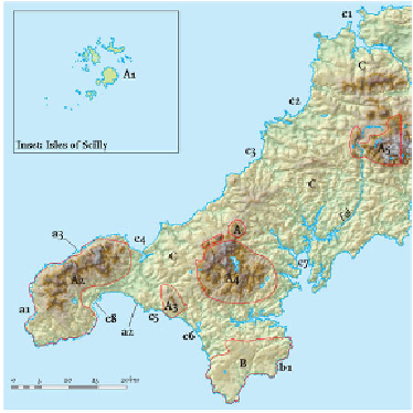
FIG
52.
Area 1, showing Landscapes A to C and specific localities mentioned in the text.
Major divisions of Landscape A are identified by
A1, A2, A3
etc., and localities are
shown as
a1, a2, a3
etc.
Land's End is the westernmost tip of mainland England. The local cliffs are made
of granite and clearly show vertical sets of fractures, probably formed when the granite
was cooling and contracting (Figs 54 and 55). Apart from the fractures, the granite is
massive compared with the strongly layered and deformed rocks into which the main
granites were intruded. Most of the northerly inland areas are exposed and windswept
moorland, though arable farming for early vegetables has developed in the valleys to
the south. The valleys eroded in the Land's End granite are distinct and often oriented
very clearly in a northwest-southeast direction. This orientation is parallel to a large
number of faults which appear to have first formed late in the Variscan mountain-
building episode. However, they must also have been active much later, after the intru-
sion of the main granite, because its margin is locally offset by faults with this trend.
The movement of superheated water along these fault systems has resulted in miner-
alisation of the bedrock, altering its resistance to erosion so that valley incision has
taken place preferentially in this direction. Tors are largely absent from the Land's End,