Geoscience Reference
In-Depth Information
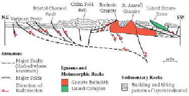
One large feature visible in the bedrock is the 'Culm fold belt' or 'synclinorium', a
large and complex downfold representing horizontal crustal convergence (Figs 39 and
40). The centre of this feature is a belt of bedrock of Carboniferous age that extends
between Bude and Exeter running across the centre and north of the Southwest Re-
gion. To the north and south of this, older (Devonian) rocks occur at the bedrock sur-
face, forming the margins of the large downfold or syncline (Fig. 37).
Culm
is an old
term much used by miners and European geologists for Carboniferous sediment, and
synclinorium
is a name for a downfold (or syncline) which contains numerous smaller
folds.
In the Lizard area, much of the bedrock consists of a distinctive group of igneous
rocks (Figs 39 and 40). These rocks cooled and solidified earlier than the main moun-
tain building, and were mostly formed by intrusion of hot molten rock in a way that
is typical of the floor of an ocean basin. The Lizard area provides one of the best
examples now visible on land in Britain of material formed originally as ocean-floor
crust. In Late Devonian times, as a result of early Variscan convergence, this large area
of oceanic crust was forced northwards over and against sedimentary rocks lying just
to the north. This shows how, in a large mountain belt, an area of crust (tens of kilo-
metres across), with a distinctive history as the floor of an ocean basin, can be uplifted
and incorporated into a mountain belt as its margins are squeezed together.
FIG
40.
Schematic cross-section representing major structures of the Variscan mountain
belt. The deep structure shown is speculative but shows how crustal shortening seen at
the surface may be related to deeper, flat-lying fractures (faults). Located on Figure 39.