Geoscience Reference
In-Depth Information
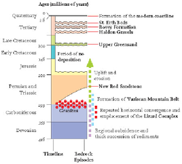
FIG
36.
Timeline diagram showing bedrock deposition and emplacement events in the
Southwest Region.
Some of the best evidence for the horizontal crustal shortening comes from ex-
amining folds that can be seen in the bedrock at many localities (Figs 41 and 42). Fold-
ing of the originally flat layers of the bedrock is a spectacular feature of many south-
western sea cliffs, and the direction of the folding gives a clear indication of the direc-
tion of the shortening that resulted. Fractures (faults) also frequently cut the bedrock,
and careful mapping makes it possible to recognise that, although some of them are
very local features, others turn out to have been flat-lying fractures across which many
kilometres of movement have taken place.
FIG
37.
Simplified geological map of the Southwest Region.