Geoscience Reference
In-Depth Information
FIG
297.
The sea cliffs at Hunstanton (Fig. 294,
c1
). (Copyright London Aerial Photo
Library)
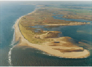
Scolt Head Island (Fig. 298) is a beautiful example of a beach barrier island:
'beach' because it is made of sand and gravel pushed into place by storm waves, and
'barrier' because it protects the land behind it from these waves. The beach barrier
forms the north rim of the island, and protected back-barrier features have formed be-
hind it. At the western end of the island (the foreground in Figure 298), advancing
storm waves have curved around as they moved up the deep tidal channel in the right
of the picture. This has, in turn, curved the beaches that form the end of the island. A
number of old curved beaches are visible in the foreground of the photograph, where
successive storms over recent centuries have added more sand and gravel to the island.
FIG
298.
Looking eastwards along Scolt Head Island (Fig. 294,
c2
). (Copyright London
Aerial Photo Library)
Since the Flandrian sea-level rise, global sea level has changed relatively little
over the last 6,000 years, and the Norfolk coastline itself has stayed in more or less the
same position. However, the plentiful supply of gravel, sand and mud moved around by
sea storms means that beach barriers such as Scolt Head Island are continually chan-
ging their shape. People who revisit stretches of the coast are always spotting year-to-
year changes in the barrier's shape, the positions of the tidal channels and the build-up
of mud in sheltered areas.
Wells-next-the-Sea (
c3
) is the only settlement on the north Norfolk coast that is
still used by commercial shipping. For about 1 km north of Wells, the construction of a
sea wall west of the main tidal channel has allowed drainage of the western back-barri-