Geoscience Reference
In-Depth Information
FIG
293.
Looking northeastwards over the Hunstanton cliffs. (Copyright Norfolk Mu-
seums and Archaeology Service & Derek A. Edwards)
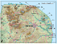
FIG
294.
Area 16, showing Landscapes
A
to
D
and localities (
b1, b2
etc.) mentioned in
the text.
Landscape B: Early Cretaceous foothills
The Early Cretaceous bedrock succession that underlies the surface blanket in west
Norfolk consists largely of Gault mudstones in the south of Area 16. However, to the
north, in the areas east of Downham Market and King's Lynn, increasing thicknesses
of sand are present, forming the Sandringham Sands and the Carstone. Through much
of this northern area, the Carstone has been used as a distinctive local building stone:
a red, brown or orange sandstone looking rather like gingerbread. The slabs or blocks
are irregular, and have generally been used to face walls, requiring brick or limestone
piers or frames to give strength and form to windows and doors. The photograph (Fig.
295) is of a new wall in Hunstanton.
The sandstone materials of the Early Cretaceous have resisted landscape erosion
more than the underlying Late Jurassic mudstones of Landscape
A
, producing low hills
often covered with acid-soil heathland vegetation. Bracken and mixed forestry, partic-
ularly extensive around the royal Sandringham estate (
b1
), have been developed for
countryside shooting activity. East of King's Lynn, around Leziate (
b2
) and Roydon
Heath, this heathland also contains an array of sand-pits, where the Sandringham Sands
have been quarried as a source of pure quartz sand.
The variety of deposits in the Nar Valley (
b3
) shows how valley pathways have
been used repeatedly as the landscape has evolved. The earliest surface-blanket depos-
its are of Anglian ice-laid material, some 450,000 years old. These are followed by
Hoxnian deposits (about 400,000 years old) that include evidence of flooding by the