Geoscience Reference
In-Depth Information
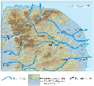
FIG
290.
Natural and man-made features of Area 16.
The drainage of the Norfolk landscape depends on low-gradient rivers in open
valleys draining to the west, north and east from the Chalk high ground of west Nor-
folk. The main westerly rivers flow into the Fens over relatively short courses, and are
comparatively small. They are, from south to north, the Little Ouse (3.0 m
3
/s), Wissey
(1.8 m
3
/s) and Nar (1.2 m
3
/s), where the mean flow figures have been measured at the
stations shown in Figure 291. In contrast, the main rivers flowing to the east coast are
distinctly longer, although water extraction leaves some of them with low mean flows.
From south to north, mean flow figures measured at the stations shown are: Waveney,
0.6 m
3
/s; Yare, 1.4 m
3
/s; Wensum, 4.0 m
3
/s and Bure, 2.2 m
3
/s. The overall drainage
divide within the Chalk hills runs from the northwestern part of the Area, inland from
Hunstanton, in a southeasterly direction to the Lopham Gap, between the Little Ouse
and the Waveney. Here, remarkably, the divide between the westerly-flowing Little
Ouse and the easterly-flowing Waveney is less than 25 m above sea level.
Some of the examples of recent changes are so clear that they merit discussing
in unusual detail below. In much earlier times, during brief periods of warmer climate
and higher sea level over the last million years or so, coastal processes are likely also
to have influenced the scenery along the edge of the Fens in west Norfolk.
FIG
291.
Valley pathways and coastal flooding zone for Area 16.
The general introduction to East Anglia at the start of this chapter summarises the
bedrock distribution (Fig. 226) and succession (Fig. 225), and this sets the scene for
consideration of the Landscapes of Area 16 (Fig. 292).