Geoscience Reference
In-Depth Information
FIG
279.
Drainage from low-lying Fenland fields is pumped into a Fenland river.
FIG
280.
The Great Ouse (left) and Flood Relief Channel (right) at Downham Market
(Fig. 275,
c6
). (Copyright Aerofilms)
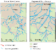
The engineering of the Fenland rivers has changed the river pattern completely.
Before the drainage work there was a complicated network of winding rivers with
many branches, reflecting the freedom of the flooding rivers to change their courses
over the very flat landscape. This has now been changed to a network of straight, re-
strained rivers (Fig. 281).
But traces of the old network remain. In Figure 282 the Little Ouse rodden shows
up beautifully as a ribbon of pale silt meandering across fields of darker peat soils.
Many smaller silt-filled ancient channels are also visible, depending on the state of
ploughing and crop-growth in the fields. The straight course of the A1102 road, run-
ning between Littleport and Shippea Hill, can be seen crossing the winding rodden,
which is marked in red on the natural rivers map in Figure 281. Houses have been built
where the road crosses the rodden, to take advantage of the silt, which makes for better
foundations than the shrinking and wasting peat soils. This rodden is clearly shown on
Ordnance Survey
Landranger
Sheet 143 (Ely and Wisbech).
FIG
281.
Natural river courses of the Fens, contrasted with the present engineered
straight courses.